Burning Palms, New South Wales facts for kids
Quick facts for kids Burning PalmsNew South Wales |
|
|---|---|

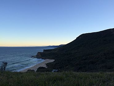
Southwestern view of the beach from Burgh Ridge Track
|
|
| Postcode(s) | 2508 |
| LGA(s) | City of Wollongong |
| State electorate(s) | Heathcote |
| Federal Division(s) | Cunningham |
Burning Palms is a beautiful beach and a special area located within the Royal National Park in New South Wales, Australia. It's found near Wollongong, which is south of Sydney. This spot is part of a larger area called Lilyvale.
Burning Palms is a popular place for people to visit, especially for a day trip. It's known for its surf club, where surfers gather, and a unique community of small cabins. One of the most exciting features is the 'figure-8' rock pools. These are natural pools shaped like the number eight, found on the rocks south of the beach.
Getting to Burning Palms
Reaching Burning Palms is an adventure in itself! You can get there by walking along a path that goes down a very steep mountain. This walk is considered moderately difficult, so it's a good challenge for hikers. The path takes you through thick forests and wide-open grassy areas. This whole area is known as Garawarra.
Historic Cabin Community
Burning Palms is home to a special group of cabins. These cabins are part of what's called the Royal National Park Coastal Cabin Communities. Along with similar cabins at nearby Little Garie and Era, this community was added to the New South Wales State Heritage Register on April 27, 2012. This means the cabins and their history are protected and recognized as important parts of the area's heritage. They show how people used to live and enjoy the coast a long time ago.
 | Audre Lorde |
 | John Berry Meachum |
 | Ferdinand Lee Barnett |


