
Bury Camp facts for kids

Location in Wiltshire
|
|
| Alternative name | Bury Wood Camp, or North Wood |
|---|---|
| Location | Wiltshire |
| Coordinates | 51°27′53″N 2°15′48″W / 51.4647°N 2.2634°W |
| History | |
| Periods | Iron Age |
| Site notes | |
| Excavation dates | yes |
| Archaeologists | Dr Denis Grant-King |
| Condition | good |
| Public access | yes |
| Identifiers | |
| NHLE | 1018385 |
| Atlas of Hillforts | 0425 |
Bury Camp is an ancient hillfort located in Wiltshire, England. It was built during the Iron Age, a time when people started using iron tools. This special type of fort is called a "multivallate" hillfort. This means it had many layers of defenses, like ditches and walls, to protect the people living inside.
The camp sits on a high piece of land called a promontory. This land is part of Colerne Down, at the edge of the Cotswold Hills. Being on a hill made it naturally strong against attackers.
Contents
What is Bury Camp?
Bury Camp covers a large area, about 9.2 hectares. That's roughly the size of 20 football fields! The camp is shaped like a triangle. It is surrounded by a ditch that is 4 meters wide and up to 1 meter deep. There's also an outer wall, called a rampart, which is up to 1.5 meters high on some sides. On the southwestern side, it's even taller, reaching up to 2 meters high.
How Was It Built?
The natural shape of the land helped protect the camp. The north and east sides had very steep slopes, making them hard to attack. On the southwestern side, where the land was flatter, the builders added more defenses. They dug another ditch, 4 meters wide and 1 meter deep. They also built another rampart, up to 2 meters high and 3 meters wide.
Many pathways cross these defenses. Some experts think this might mean the fort was never fully finished. The main entrance on the southwestern side is believed to be a newer addition. There were also older entrances. One in the northeast corner had a funnel shape, leading down a steep path into the valley. Another entrance on the northwest side also had inward-turning walls, creating a similar funnel shape.
What Did Archaeologists Find?
Archaeologists are like history detectives who dig up clues from the past. In 1959, Dr. Denis Grant-King led excavations at Bury Camp. They found excellent examples of Iron Age drystone walls. These are walls built without mortar, using carefully fitted stones.
They also found signs of an even older structure at the northeast entrance. This showed that the entrance was changed and made wider later on. At the northwest entrance, they found four holes where large wooden posts once stood. One cylindrical hole, 0.66 meters deep, was likely for a gate post.
Tools and Pottery
The fort was built around 350 BC. However, archaeologists found much older tools there. They discovered flint tools from the Neolithic and Mesolithic periods. These tools included scrapers, cores, and flakes. This tells us that people were using this area long before the Iron Age fort was built.
They also found grinding stones, called querns. These were used to grind grains into flour. One stone might have been used for polishing axes. In 1960, 175 pieces of pottery were found. Almost all of them were plain and undecorated.
Animal Bones
Archaeologists found very few human bones at the site. But they found between 400 and 500 animal bone fragments! Most of these were from farm animals like sheep, goats, cattle, pigs, horses, and dogs. They also found bones from large birds, probably swans or geese. Some bones from deer, fox, rabbit, and vole were also present.
The large number of domestic animal bones suggests that the people living at Bury Camp mainly raised animals for food. Hunting wild animals probably wasn't a big part of their diet.
Where is Bury Camp?
Bury Camp is located near the village of North Wraxall in Wiltshire. It sits at a height of 145 meters above sea level. The ancient Roman road called the Fosse Way passes very close to the west of the site. Today, Bury Camp is a protected national monument.
Images for kids
-
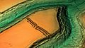
A 3D view of Bury Camp using a digital terrain model.

