
Cabo Touriñán facts for kids

Cabo Touriñán is a small piece of land that sticks out into the Atlantic Ocean. It is the most western point of mainland Spain! You can find it in a town called Muxía, which is in the province of A Coruña in the region of Galicia. Many people who walk the famous Camino de Santiago pilgrimage often extend their journey to Cabo Touriñán. They walk to this cape after reaching Santiago de Compostela to see the "end of the world" where the land meets the sea.
Exploring the Cape's Landscape
This cape is a small peninsula that stretches about 1 kilometer (0.6 miles) into the sea. Its narrowest part is only 150 meters (490 feet) wide. The highest point of the cape is 93 meters (305 feet) above sea level.
The rocks here are made of granite. Over time, the ocean has worn away the granite, creating smooth, rounded stones called coídos. It has also formed stony bars and small islands, like the one known as A Ínsua on the west side.
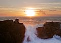
The westernmost tip of the cape is called Os Buxeirados. It has a series of rocks that extend 300 to 400 meters (980 to 1,300 feet) into the sea. These rocks are known as A Laxe de Buxeirados or Bajos de Buxeirados. They have been very dangerous for ships, causing several serious shipwrecks in the past.
Because the landscape is so rugged, the main plants you'll see are tough, thorny bushes like gorse (Ulex europaeus). On the northern side of the cape, there is a lighthouse. It was built on December 15, 1898, to help guide ships safely past the dangerous rocks.
Where Does the Name Come From?
The name "Touriñán" comes from a nearby village called Touriñán. Historians believe the name itself comes from an old Latin name, possibly "Taurinius" or "Taurinianus."
Gallery
-
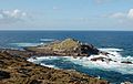
Illa do Castelo.
-
-


See also
 In Spanish: Cabo Touriñán para niños
- Cape Finisterre
- Extreme points of Spain
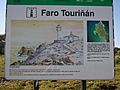
- Touriñán Lighthouse
