Cactus Flats, Arizona facts for kids
Quick facts for kids
Cactus Flats, Arizona
|
|
|---|---|

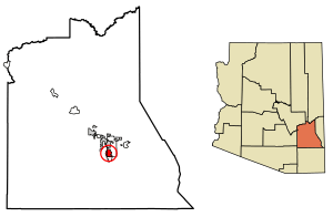
Location of Cactus Flats in Graham County, Arizona.
|
|
| Country | United States |
| State | Arizona |
| County | Graham |
| Area | |
| • Total | 6.27 sq mi (16.23 km2) |
| • Land | 6.22 sq mi (16.11 km2) |
| • Water | 0.05 sq mi (0.13 km2) |
| Elevation | 3,124 ft (952 m) |
| Population
(2020)
|
|
| • Total | 1,524 |
| • Density | 245.09/sq mi (94.63/km2) |
| Time zone | UTC-7 (Mountain (MST)) |
| Area code(s) | 928 |
| GNIS feature ID | 2582744 |
Cactus Flats is a small community located in Graham County, Arizona, in the United States. It's not an official town or city. Instead, it's called a census-designated place (CDP). This means it's an area that the U.S. Census Bureau defines for gathering population data.
As of the 2020 census, about 1,524 people lived in Cactus Flats. It's a quiet place, known for its desert environment and the unique plants that grow there, like cacti!
About Cactus Flats
Cactus Flats is found in the southeastern part of Arizona. It sits at an elevation of 3,124 feet (about 952 meters) above sea level. This elevation means it's higher than many desert areas, which can affect its climate.
The community covers an area of about 6.27 square miles (16.23 square kilometers). Most of this area is land, with a very small amount of water. It's part of the Mountain Time Zone, which is the same time zone as many other places in the western U.S.
Population Facts
The U.S. Census Bureau collects information about where people live every ten years. Cactus Flats was first recognized as a census-designated place in the 2010 census.
Here's how its population has changed:
| Historical population | |||
|---|---|---|---|
| Census | Pop. | %± | |
| 2010 | 1,518 | — | |
| 2020 | 1,524 | 0.4% | |
| U.S. Decennial Census | |||
As you can see, the population stayed pretty steady between 2010 and 2020. This shows that Cactus Flats is a stable community.
See also
 In Spanish: Cactus Flats (Arizona) para niños


