
Calabazas, San Sebastián, Puerto Rico facts for kids
Quick facts for kids
Calabazas
|
|
|---|---|
|
Barrio
|
|

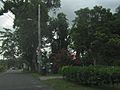
Street and homes in Calabazas
|
|

Location of Calabazas within the municipality of San Sebastián shown in red
|
|
| Lua error in Module:Location_map at line 416: Malformed coordinates value. | |
| Commonwealth | |
| Municipality | |
| Area | |
| • Total | 5.69 sq mi (14.7 km2) |
| • Land | 5.69 sq mi (14.7 km2) |
| • Water | 0 sq mi (0 km2) |
| Elevation | 643 ft (196 m) |
| Population
(2010)
|
|
| • Total | 2,768 |
| • Density | 486.5/sq mi (187.8/km2) |
| Source: 2010 Census | |
| Time zone | UTC−4 (AST) |
Calabazas is a community, also known as a barrio, located in the town of San Sebastián, Puerto Rico. In 2010, about 2,768 people lived there. It is a part of Puerto Rico, which is a commonwealth of the United States.
Contents
History of Calabazas
Puerto Rico became a territory of the United States after the Spanish–American War. This happened because of the Treaty of Paris of 1898. In 1899, the United States government counted the people in Puerto Rico. They found that 746 people lived in the Calabazas community.
In 2017, Hurricane Maria caused a lot of damage in Puerto Rico. The road leading to the Calabazas bridge, which crosses the Culebrinas River, was badly damaged. There was a lot of debris, like fallen trees and trash, piled up around the bridge.
Another strong storm, Hurricane Fiona, hit Puerto Rico in 2022. This Category 4 hurricane caused significant problems and damage in many areas, including Calabazas.
A cemetery called Pepino Memorial Park is also located in Calabazas.
Understanding Sectors in Calabazas
In Puerto Rico, barrios are like small local areas. These barrios are then divided into even smaller places called sectores (which means sectors in English).
These sectors can have different names. Some are simply called sector, while others might be named urbanización, reparto, barriada, or residencial. Each name describes a different type of community or neighborhood.
Here are some of the sectors you can find in the Calabazas barrio:
- Carretera 111
- Carretera 4435
- Residencial Jardines de Piedras Blancas
- Sector Audeliz Torres
- Sector Bartolo Cordero
- Sector Cataño
- Sector El Refugio
- Sector Jandino Ruiz
- Sector La Loma
- Sector Los Tanques
- Sector Lupe Mártir
- Sector Mamey
- Sector Orta
- Sector Pablo Nieves (Los Pinos)
- Sector Quinto Ríos
- Sector Rancho Grande
- Sector Rubén Hernández
- Sector Toño Mestre
- Urbanización Jardines Villy Ana
- Urbanización Raholisa
- Urbanización Venturini
- Urbanización Villas de Piedras Blancas
Population Changes in Calabazas
Demographics is the study of how populations change over time. This includes how many people live in a place. The numbers below show how the population of Calabazas has grown over the years, according to the U.S. Census.
| Historical population | |||
|---|---|---|---|
| Census | Pop. | %± | |
| 1900 | 746 | — | |
| 1980 | 1,772 | — | |
| 1990 | 2,126 | 20.0% | |
| 2000 | 2,458 | 15.6% | |
| 2010 | 2,768 | 12.6% | |
| U.S. Decennial Census 1899 (shown as 1900) 1910-1930 1930-1950 1980-2000 2010 |
|||
Gallery
- Scenes in Calabazas
-
Heading east on PR-435
-
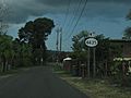
Highway 4435
-
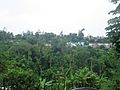
Calabazas
-
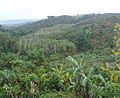
View of ravine near Culebrinas River
-
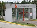
Pepino Memorial Park


See also
 In Spanish: Calabazas (San Sebastián) para niños
- Culebrinas River
- List of communities in Puerto Rico
- List of barrios and sectors of San Sebastián, Puerto Rico
