
California Historical Landmarks in Amador County facts for kids
Did you know that California has many special places that are protected because of their history? These are called California Historical Landmarks! They help us remember important events and people from the past. In Amador County, California, there are many such landmarks that tell stories about the Gold Rush, early towns, and the people who lived here long ago. Let's explore some of these amazing historical spots!
Contents
Exploring Amador County's Historic Treasures
Amador County is full of history, especially from the exciting days of the California Gold Rush. Many of its landmarks are old mines, towns, and buildings that played a big part in shaping California.
Gold Rush Era Landmarks
The search for gold brought many people to California, and Amador County was a busy place during this time. Many landmarks here are connected to the Gold Rush.
Famous Mines: Argonaut and Kennedy
Two of the most famous gold mines in California, the Argonaut Mine and the Kennedy Mine, are located near Jackson. These mines were incredibly deep and produced a huge amount of gold. They were also known for their advanced mining techniques, like the giant Kennedy Wheels that helped bring up the ore.


Bustling Gold Rush Towns
Several towns in Amador County started as busy Gold Rush settlements and are now historical landmarks themselves.
- Drytown: This was one of the very first gold mining towns in Amador County. It was a lively place with many businesses and people hoping to strike it rich.

- Sutter Creek: Known as the "Jewel of the Mother Lode," Sutter Creek was another important mining town. It still has many beautiful old buildings that show what life was like back then.

- Volcano: This unique town got its name from its bowl-shaped valley, which looks like a volcano crater. It was a very important and busy town during the Gold Rush, even having its own newspaper and a theater.

- Oleta (Old Fiddletown): Fiddletown was a small but interesting mining town. It was known for its Chinese community and its unique name, which some say came from the fiddles played by its early residents.

Important Trading Posts
As people moved into the area, places to buy and sell goods became very important.
- Butte Store: Located on State Highway 49, this store was a key trading spot for miners and settlers in the area. It helped supply the growing communities.

- D. Stewart Co. Store: In Ione, this store was another vital center for trade and supplies, serving the local community and miners.

Life and Community in Early Amador
Beyond gold mining, these landmarks also tell us about how communities were built and how people lived their daily lives.
Historic Churches and Meeting Places
Churches and community halls were central to early settlements, providing places for worship, meetings, and social gatherings.
- Community Methodist Church of Ione: This beautiful church in Ione has been a spiritual center for the community for many years. It's also listed on the National Register of Historic Places, showing its national importance.

- Pioneer Hall: Located in Jackson, Pioneer Hall was an important meeting place for early residents. It likely hosted many community events and discussions.
Pioneer Life and Journeys
Life for pioneers was tough, and some landmarks remind us of their difficult journeys and daily struggles.
- Maiden's Grave: This sad but important site on Carson Pass marks the grave of a young woman who died during the journey west. It reminds us of the dangers and hardships faced by pioneers.
- Old Emigrant Road: This road was part of the historic trails used by pioneers traveling to California. It was a crucial path for many seeking new lives during the Gold Rush.

Early California Innovations
Some landmarks highlight the cleverness and hard work of early Californians.
- Knight Foundry: Located in Sutter Creek, the Knight Foundry is a very special place. It's one of the last water-powered foundries in the United States! A foundry is a place where metal is melted and shaped. This one used water power to run its machinery, which was very advanced for its time.

Unique Historical Sites
Amador County also has landmarks that represent different aspects of its long history, from ancient times to more recent developments.
Ancient Native American Sites
Long before the Gold Rush, Native Americans lived in this area.
- Chaw'se Roundhouse: This landmark is part of the Indian Grinding Rock State Historic Park. A roundhouse is a traditional Native American building used for ceremonies and community gatherings. It helps us understand the rich culture of the Miwok people who lived here.
Other Notable Sites
- Preston Castle: This impressive building in Ione was originally the Preston School of Industry, a reform school for young men. It's known for its unique architecture and long history.

- Site of the first amateur astronomical observatory of record in California: In Volcano, this site marks where someone set up the very first telescope in California for looking at the stars! It shows how early settlers were interested in science and the world around them.
- Site of Jackson's Pioneer Jewish Synagogue: This site in Jackson marks where an early Jewish synagogue stood. It shows the diverse communities that came to California during the Gold Rush and how different groups built their lives and places of worship.
These landmarks in Amador County are like open history books, each telling a unique story about California's past. Visiting them helps us connect with the people and events that shaped this amazing state.
Images for kids
-
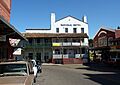
A historic view of Jackson Gate, an important entry point to Jackson.

