
California Historical Landmarks in Solano County facts for kids
Welcome to Solano County, California! This area is full of amazing places that tell stories about the past. These special spots are called California Historical Landmarks. They are like official markers that show where important events happened or where significant buildings once stood.
By exploring these landmarks, you can learn about California's early days, its military history, and how communities grew. Get ready to discover some cool historical sites right here in Solano County!
Contents
Exploring Solano County's Historic Places
Solano County is home to many historical landmarks, each with its own unique story. Let's take a closer look at some of the most interesting ones.
Benicia's Rich History
The city of Benicia was once a very important place in California's history. It even served as the state capital for a short time! Many landmarks here remind us of its past.
The Old Capitol Building
The Benicia Capitol is a super important landmark. From 1853 to 1854, this building was where California's government met. Imagine lawmakers debating and making decisions right here! It's a great place to visit and step back in time.

Benicia Arsenal
The Benicia Arsenal was a major military base. It was used by the U.S. Army for over a century, starting in 1851. Soldiers stored weapons and supplies here. It played a big role in many conflicts, including the Civil War and World War II. Part of it is also on the NRHP list, which means it's recognized nationally for its historical value.

Benicia Barracks
Near the Arsenal were the Benicia Barracks. These were the living quarters for the soldiers stationed at the Arsenal. They were an important part of the military community in Benicia.
Historic Churches and Lodges
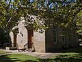
Benicia also has several historic religious buildings. The First Presbyterian Church of Benicia and Saint Paul's Episcopal Church are both very old. They show the early growth of the community. The Benicia Lodge No. 5 is another historic building that was important for local social groups.


Other Benicia Landmarks
The Benicia Seminary was an early educational institution. The Fischer-Hanlon House is a historic home that gives us a peek into how people lived long ago. The Matthew Turner Shipyard Park remembers a famous shipbuilder who worked in Benicia.
Vallejo and Mare Island
The city of Vallejo also has a significant place in California's history, especially with its connection to the Navy.
The Mare Island Naval Shipyard in Vallejo was the very first U.S. naval base on the Pacific Ocean. It opened in 1854! For many years, ships were built and repaired here. It was a vital spot for the Navy, especially during wars. This site is also on the NRHP list.

Former California State Capitol
Before Benicia, Vallejo was also a state capital for a short time in 1852. The site of the Former California State Capitol reminds us of this early period.
Other Important Sites
Beyond Benicia and Vallejo, Solano County has other unique historical landmarks.
Rockville Stone Chapel
The Rockville Stone Chapel is a beautiful and historic church located in Rockville. It was built in 1856 using local stone. It's a peaceful place that shows early pioneer craftsmanship.

University of California Experimental Farm
Near Winters, you'll find the University of California Experimental Farm. This farm has been used for agricultural research for a very long time. It helps us understand how to grow crops better.
Vaca-Peña Adobe
The Vaca-Peña Adobe in Vacaville is one of the oldest buildings in Solano County. It was built by early settlers. An adobe is a type of building made from sun-dried earth bricks. It's a great example of early California architecture.
These landmarks help us remember and learn about the people and events that shaped Solano County and California. Visiting them is like taking a journey back in time!
Images for kids
-
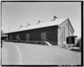
A historic building at the Benicia Arsenal.
-
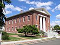
The historic Benicia Capitol building.
-
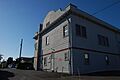
Benicia Lodge No. 5, a historic meeting place.
-
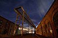
Mare Island Naval Shipyard at night.
-
The historic Rockville Stone Chapel.
-
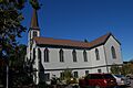
Saint Paul's Episcopal Church in Benicia.
