Calumet-Norvelt, Pennsylvania facts for kids
Quick facts for kids
Calumet-Norvelt
|
|
|---|---|
|
Unincorporated community
|
|

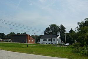
Norvelt Post Office and Norvelt Union Church
Mount Pleasant Road |
|
| Etymology: Calumet Coke Company (Calumet) and Eleanor Roosevelt (Norvelt) | |
| Country | United States |
| State | Pennsylvania |
| County | Westmoreland |
| Township | Mount Pleasant |
| Founded | 1888 (Calumet) and 1934 (Norvelt) |
| Area | |
| • Total | 1.5 sq mi (4 km2) |
| • Land | 1.5 sq mi (4 km2) |
| • Water | 0.0 sq mi (0 km2) |
| Elevation | 1,000 ft (300 m) |
| Population
(2000)
|
|
| • Total | 1,682 |
| • Density | 1,120/sq mi (433/km2) |
| Time zone | UTC-5 (EST) |
| • Summer (DST) | UTC-4 (EDT) |
| ZIP code |
15621 (Calumet) and 15674 (Norvelt)
|
| Area code(s) | 724 |
Calumet-Norvelt was a special area in Westmoreland County, Pennsylvania, United States. It was called a census-designated place (CDP). This means it was a place the US Census Bureau defined for counting people.
For the 2010 census, this area was split into two separate communities: Calumet and Norvelt. Even though the government treated them as one, they were quite different. Each community shows a different part of how the Great Depression affected people in rural Pennsylvania.
Calumet was a "patch town." This was a type of town built by a company to house its workers, usually miners, as cheaply as possible. When the Calumet mine closed during the Great Depression, it caused huge problems. People had no jobs and no money. Back then, there were no unemployment payments or welfare help.
Norvelt, on the other hand, was created during the Great Depression by the US government. It was a model community. The idea was to help unemployed coal miners have a better life.
Where is Calumet-Norvelt Located?
Calumet-Norvelt is an unincorporated community. This means it's not a separate city or town with its own government. It's part of Mount Pleasant Township. You can find it at these coordinates: 40°12′49″N 79°29′35″W / 40.21361°N 79.49306°W.
The area covers about 1.5 square miles (3.9 square kilometers). All of this area is land.
The Story of Calumet
Calumet was started in 1888 by the Calumet Coke Company. They built houses for their workers. The town had twenty double-houses, twelve single-family houses, and some shops and industrial buildings.
The workers mined coal. They also operated ovens that made coke (fuel). Coke is a type of fuel made from coal. In 1894, Calumet was the site of a difficult coal miners’ strike. This was against the H. C. Frick Coke Company.
The coke works closed in the 1920s. The mine closed in the early 1930s. This happened during the Great Depression. It caused huge problems for the workers and their families.
The Story of Norvelt
Norvelt was first called Westmoreland Homesteads. It was created on April 13, 1934. This was part of a plan to build "subsistence homesteads" under the National Industrial Recovery Act.
These communities aimed to help people in rural areas live better. They could grow much of their own food. The hope was to improve life for unemployed coal miners. Many of these miners came from nearby Calumet and other similar "patch towns."
Each home lot in Norvelt was at least 1.7 acres (0.69 hectares). Other land was set aside for a cooperative farm. This meant people could work together on a farm. The community's design and house plans were made by Paul Bartholomew. He was an architect who designed many buildings in Greensburg.
In 1937, the community's name changed to Norvelt. This happened after a visit from Eleanor Roosevelt. She was the wife of President Franklin D. Roosevelt. The name Norvelt combines parts of her name: EleaNOR RooseVELT.
See also
 In Spanish: Calumet-Norvelt para niños


