Camiri facts for kids
Quick facts for kids
Camiri
|
|
|---|---|
|
City
|
|
| Nickname(s):
"Capital Petrolera de Bolivia"
|
|
| Country | |
| Department | |
| Province | Cordillera Province |
| Municipality | Camiri Municipality |
| Area | |
| • Total | 22 km2 (8 sq mi) |
| • Land | 19 km2 (7 sq mi) |
| • Water | 3 km2 (1 sq mi) |
| Elevation | 812 m (2,664 ft) |
| Population
(2012)
|
|
| • Total | 35,712 |
| • Density | 1,620/km2 (4,200/sq mi) |
| Time zone | UTC-4 (BOT) |
| Area code(s) | +591 3952 |
| Climate | Cwa |
| Website | Official website: http://www.camiri.net/ |
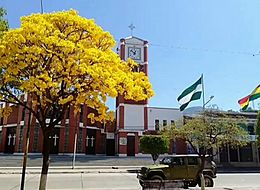
Camiri is a city in Bolivia, located in the Santa Cruz Department. It is sometimes called the "Oil Capital of Bolivia" because of its importance in the oil industry. The city is home to about 65,897 people, known as "Camireños."
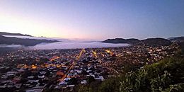
Camiri sits by the Parapeti River in a small valley. It is surrounded by gentle hills to the east, north, and south. To the west, you can see the Aguarague mountain range.
The area around Camiri is part of the Gran Chaco ecosystem. This means it has dry subtropical forests with short trees. There are many plants that can live in dry conditions. This region is also home to a wide variety of wildlife.
In 2007, some local people in Camiri held protests. They wanted the natural gas industry to be more controlled by the country. They also wanted new facilities built for YPFB, which is Bolivia's national oil company.
Camiri's Climate
Camiri has a humid subtropical climate. This type of climate usually has warm, humid summers and mild winters.
| Climate data for Camiri (Camiri Airport), elevation 810 m (2,660 ft) | |||||||||||||
|---|---|---|---|---|---|---|---|---|---|---|---|---|---|
| Month | Jan | Feb | Mar | Apr | May | Jun | Jul | Aug | Sep | Oct | Nov | Dec | Year |
| Mean daily maximum °C (°F) | 31.5 (88.7) |
30.5 (86.9) |
29.5 (85.1) |
27.2 (81.0) |
24.8 (76.6) |
23.6 (74.5) |
24.6 (76.3) |
27.5 (81.5) |
29.6 (85.3) |
31.6 (88.9) |
32.0 (89.6) |
31.8 (89.2) |
28.7 (83.6) |
| Daily mean °C (°F) | 25.3 (77.5) |
24.6 (76.3) |
23.8 (74.8) |
21.7 (71.1) |
19.1 (66.4) |
17.3 (63.1) |
16.9 (62.4) |
19.0 (66.2) |
21.6 (70.9) |
24.4 (75.9) |
25.1 (77.2) |
25.4 (77.7) |
22.0 (71.6) |
| Mean daily minimum °C (°F) | 19.0 (66.2) |
18.8 (65.8) |
18.1 (64.6) |
16.1 (61.0) |
13.4 (56.1) |
10.9 (51.6) |
9.2 (48.6) |
10.4 (50.7) |
13.4 (56.1) |
17.1 (62.8) |
18.2 (64.8) |
19.0 (66.2) |
15.3 (59.5) |
| Average precipitation mm (inches) | 159.9 (6.30) |
141.1 (5.56) |
110.8 (4.36) |
58.3 (2.30) |
23.0 (0.91) |
12.0 (0.47) |
7.5 (0.30) |
6.1 (0.24) |
18.0 (0.71) |
37.1 (1.46) |
71.5 (2.81) |
146.8 (5.78) |
792.1 (31.2) |
| Average precipitation days | 10.1 | 9.5 | 9.2 | 7.5 | 6.4 | 5.3 | 2.9 | 1.8 | 2.7 | 4.7 | 7.0 | 9.3 | 76.4 |
| Average relative humidity (%) | 71.0 | 72.8 | 74.9 | 76.3 | 76.3 | 72.6 | 64.5 | 54.7 | 51.4 | 56.3 | 59.8 | 66.9 | 66.5 |
| Source: Servicio Nacional de Meteorología e Hidrología de Bolivia | |||||||||||||
See also
 In Spanish: Camiri para niños
 | Anna J. Cooper |
 | Mary McLeod Bethune |
 | Lillie Mae Bradford |


