Campamento, Antioquia facts for kids
Quick facts for kids
Campamento, Antioquia
|
|||
|---|---|---|---|
|
Municipality and town
|
|||
|
|||

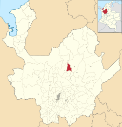
Location of the municipality and town of Campamento, Antioquia in the Antioquia Department of Colombia
|
|||
| Country | |||
| Department | |||
| Subregion | Northern | ||
| Area | |||
| • Municipality and town | 200 km2 (80 sq mi) | ||
| • Urban | 0.2 km2 (0.08 sq mi) | ||
| Elevation | 1,700 m (5,600 ft) | ||
| Population | |||
| • Municipality and town | 9,091 | ||
| • Urban | 2,875 | ||
| Time zone | UTC-5 (Colombia Standard Time) | ||
| Website | http://www.campamento-antioquia.gov.co | ||
Campamento is a small town and municipality in Colombia. It is located in the Antioquia region. This town is part of the Northern Antioquia area. It sits high up, about 1,700 meters (5,600 feet) above sea level, right in the middle of the Andes mountains.
Campamento shares its borders with other towns. To the north, it meets Yarumal and Anorí. Anorí is also to its east. To the south, it borders Angostura, and to the west, it meets Yarumal again. Campamento is often called the "Cradle of Independence of Antioquia." Its name likely comes from the fact that it was a "camp" for travelers and traders. These people used to move between the northern and northeastern parts of Antioquia.
A Look Back: Campamento's History
Before Europeans arrived, the area where Campamento is now was home to native tribes. These included the Nechí and Ituango people. In the mid-1600s, people started moving to the northern part of the department. They were looking for gold. However, Campamento itself was not settled until much later. The first settlers arrived in 1827 from a nearby town called Yarumal.
Becoming a Town
In 1830, Campamento became a "Parish" within the Municipality of Yarumal. This was an important step. Just five years later, in 1835, Campamento was officially made a municipality. This decision was made by the governor of Antioquia at the time, Don Juan de Dios Aranzazu. This meant Campamento became its own independent town, separate from Yarumal.
The name Campamento has a special meaning. It was given after a big battle called the Battle of White Chorros. This battle happened on February 12, 1820. In this fight, General Jose Maria Cordova won against General Francisco Warletta. This victory helped end the last Spanish strongholds in Antioquia.
Early Days and Growth
The first people to settle in Campamento came from Yarumal in 1827. They were encouraged by a priest named Jose Antonio Palace Isaza. He is often seen as the founder of the town. In 1830, the parish was created. Then, in 1835, it officially became a municipality.
The first church in Campamento was sadly destroyed by a fire. The church you see today was finished in the mid-1900s, probably around 1954. Over the years, Campamento grew and got more modern services.
- In 1897, the first telegraph line connected Yarumal and Campamento. This made communication much faster.
- Electric light came to the municipality in 1939. This was a big change for the town.
- In 1943, a new road connecting Yarumal with Campamento was opened. This made travel and trade much easier.
See also
 In Spanish: Campamento (Antioquia) para niños
 | Shirley Ann Jackson |
 | Garett Morgan |
 | J. Ernest Wilkins Jr. |
 | Elijah McCoy |


