Carthage, Arkansas facts for kids
Quick facts for kids
Carthage, Arkansas
|
|
|---|---|

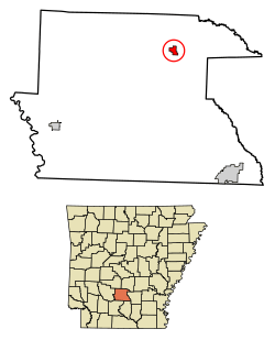
Location of Carthage in Dallas County, Arkansas.
|
|
| Country | United States |
| State | Arkansas |
| County | Dallas |
| Area | |
| • Total | 0.99 sq mi (2.56 km2) |
| • Land | 0.99 sq mi (2.56 km2) |
| • Water | 0.00 sq mi (0.00 km2) |
| Elevation | 308 ft (94 m) |
| Population
(2020)
|
|
| • Total | 222 |
| • Density | 224.47/sq mi (86.68/km2) |
| Time zone | UTC-6 (Central (CST)) |
| • Summer (DST) | UTC-5 (CDT) |
| ZIP code |
71725
|
| Area code(s) | 870 |
| FIPS code | 05-11830 |
| GNIS feature ID | 2404003 |
Carthage is a small town located in Dallas County, Arkansas, in the United States. It's a quiet place with a friendly community. In 2020, about 222 people lived there.
Contents
About Carthage
Carthage is a town in the state of Arkansas. It is part of Dallas County. The town is known for its peaceful atmosphere.
Where is Carthage?
Carthage is located in the central part of Arkansas. It is about 308 feet (94 meters) above sea level. The town covers a total area of about 0.99 square miles (2.56 square kilometers). All of this area is land, with no large bodies of water.
People of Carthage
The number of people living in Carthage has changed over the years. A "census" is like a big count of everyone living in a place. It happens every ten years.
Population Changes Over Time
The population of Carthage has varied. Here's how the number of people living there has changed:
| Historical population | |||
|---|---|---|---|
| Census | Pop. | %± | |
| 1910 | 386 | — | |
| 1920 | 532 | 37.8% | |
| 1930 | 558 | 4.9% | |
| 1940 | 687 | 23.1% | |
| 1950 | 533 | −22.4% | |
| 1960 | 528 | −0.9% | |
| 1970 | 566 | 7.2% | |
| 1980 | 568 | 0.4% | |
| 1990 | 452 | −20.4% | |
| 2000 | 442 | −2.2% | |
| 2010 | 343 | −22.4% | |
| 2020 | 222 | −35.3% | |
| U.S. Decennial Census 2014 Estimate |
|||
As you can see, the population was highest in 1940. It has slowly decreased since then.
Who Lives in Carthage?
In 2020, the town had 222 residents. Most people in Carthage are Black or African American. About 80.63% of the population identified as Black or African American. About 13.51% of the people were White. A small number of people were of other races or mixed races. About 1.80% of the population was Hispanic or Latino.
In 2000, there were 159 households in Carthage. A household is a group of people living together. Many households had children under 18. The average household had about 2.45 people.
The people in Carthage are of different ages. In 2000, about 25.6% of the population was under 18 years old. About 23.5% were 65 years or older. The average age in Carthage was 40 years old.
Getting Around Carthage
Two main state highways pass through Carthage. These roads help people travel to and from the town.
Main Roads
- Arkansas Highway 48 runs to the east of Carthage.
- Arkansas Highway 229 is located to the south.
Schools in Carthage
Students in Carthage attend schools in the Malvern School District.
Local Schools
Children living in Carthage go to schools in Malvern. These include:
- Malvern Elementary School
- Wilson Intermediate School
- Malvern Middle School
- Malvern High School
Before 2004, Carthage had its own school district. On July 1, 2004, the Carthage School District joined with the Malvern School District.
See also
 In Spanish: Carthage (Arkansas) para niños
 | Anna J. Cooper |
 | Mary McLeod Bethune |
 | Lillie Mae Bradford |

