Carurú facts for kids
Quick facts for kids
Carurú
|
||
|---|---|---|
|
Municipality and town
|
||
|
||

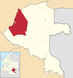
Location of the municipality and town of Carurú in Vaupés, Colombia
|
||
| Country | ||
| Department | ||
| Erected | 7 August 1993 | |
| Area | ||
| • Municipality and town | 6,982 km2 (2,696 sq mi) | |
| Elevation | 194 m (636 ft) | |
| Population
(2015)
|
||
| • Municipality and town | 3,327 | |
| • Density | 0.47651/km2 (1.23416/sq mi) | |
| • Urban | 635 | |
| Time zone | UTC-5 (Colombia Standard Time) | |
Carurú is a town and a type of local government area called a municipality in Colombia. It is located in the Vaupés region of the country. The town sits on the north side of the Vaupés River. This area is part of the Amazon natural region, known for its amazing rainforests.
Where is Carurú?
Carurú is found in the southeastern part of Colombia. It is deep within the Amazon rainforest. The town is right next to the Vaupés River. This river is a major waterway in the region.
Getting Around Carurú
Getting to Carurú is quite unique! The town has its own airport, called Carurú Airport. This is the main way people travel to and from Carurú. There are no roads connecting Carurú to other parts of Colombia. The only other way to travel is by boat on the Vaupés River. This means the river is very important for moving goods and people.
Quick Facts About Carurú
- Carurú became a municipality on August 7, 1993.
- The total area of Carurú municipality is about 6,982 square kilometers.
- In 2015, the total population was around 3,327 people.
- About 635 people lived in the main urban area of the town.
- Carurú is located about 194 meters (636 feet) above sea level.
See also
 In Spanish: Carurú para niños
 | Jewel Prestage |
 | Ella Baker |
 | Fannie Lou Hamer |


