Casimiro Castillo facts for kids
Quick facts for kids
Casimiro Castillo
|
|
|---|---|
|
Municipality
|
|

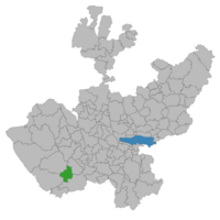
Location of the municipality in Jalisco
|
|
| Country | |
| State | Jalisco |
| Area | |
| • Total | 522.7 km2 (201.8 sq mi) |
| Population
(2020 census)
|
|
| • Total | 20,548 |
| • Density | 39.311/km2 (101.816/sq mi) |
Casimiro Castillo is a municipality located in the state of Jalisco, in central-western Mexico. A municipality is like a local government area. It helps manage the towns and villages within its borders.
The municipality covers an area of 522.7 square kilometers. That's about 201.8 square miles. As of the 2020 census, about 20,548 people live in Casimiro Castillo.
Localities
Casimiro Castillo municipality includes several smaller towns and villages. Here are some of the main ones and their populations from the 2020 census:
| Name | Population (2020 census) |
|---|---|
| La Resolana | 11,543 |
| Lo Arado | 3,140 |
| Tecomates | 1,394 |
| Piedra Pesada | 1,110 |
| El Zapotillo | 872 |
| El Chico | 787 |
| Coyamel | 429 |
| Francisco I. Madero | 284 |
See also
 In Spanish: Municipio de Casimiro Castillo para niños
Black History Month on Kiddle
African-American Ballerinas:
 | Precious Adams |
 | Lauren Anderson |
 | Janet Collins |

All content from Kiddle encyclopedia articles (including the article images and facts) can be freely used under Attribution-ShareAlike license, unless stated otherwise. Cite this article:
Casimiro Castillo Facts for Kids. Kiddle Encyclopedia.

