Cavalli Islands facts for kids

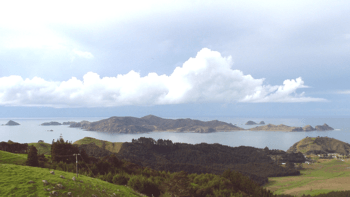
The Cavallis. The knobby hill to the right on the mainland is at the northern extremity of Matauri Bay.
|
|
| Geography | |
|---|---|
| Location | Matauri Bay Whangaroa |
| Coordinates | 35°0′S 173°57′E / 35.000°S 173.950°E |
| Total islands | 27 |
| Area | 4.5 km2 (1.7 sq mi) |
| Highest elevation | 177 m (581 ft) |
| Administration | |
The Cavalli Islands are a small group of islands located off the coast of northern New Zealand. They are found near Whangaroa on Northland's East Coast. These islands are about 3 kilometers (1 mile) east of Matauri Bay on the mainland.
Contents
Exploring the Cavalli Islands
The Cavalli Islands are made up of several islands. The largest one is called Motukawanui. It covers about 3.55 square kilometers.
There are also several smaller islands. These include Motutapere, Panaki, Nukutaunga, Haraweka, Motuharakeke, and Motukawaiti. Motukawanui is a special nature reserve. Some of the smaller islands are owned by private individuals.
How the Islands Got Their Name
The Cavalli Islands were named by Captain James Cook. He was a famous explorer. He named them on December 27, 1769, during his first big journey of discovery.
In his travel journal, Captain Cook wrote about meeting some Māori people. They "sold us some fish—Cavallys as they are called." Because of this, he decided to give the islands the same name. Captain Cook was probably talking about a type of fish called trevally. These fish are very common near the islands. The Māori people call this fish araara.
The Rainbow Warrior Shipwreck
On December 2, 1987, something important happened near the islands. The hull of the Rainbow Warrior ship was placed in the water. This ship belonged to Greenpeace, an environmental group.
The ship's hull was sunk between Matauri Bay and the Cavalli Islands. It was put there for two main reasons. First, it became a popular spot for scuba divers. Second, it created a safe place for fish to live. It is now a special fish sanctuary.
See also
 In Spanish: Islas Cavalli para niños
 | Precious Adams |
 | Lauren Anderson |
 | Janet Collins |

