
Matauri Bay facts for kids
Quick facts for kids
Matauri Bay
|
|
|---|---|

Matauri Bay
|
|
| Country | New Zealand |
| Region | Northland Region |
| District | Far North District |
| Ward | Bay of Islands/Whangaroa |
| Community | Bay of Islands-Whangaroa |
| Subdivision | Whangaroa |
| Electorates |
|
| Area | |
| • Total | 3.54 km2 (1.37 sq mi) |
| Population
(June 2023)
|
|
| • Total | 330 |
| • Density | 93.2/km2 (241/sq mi) |
Matauri Bay (also called Mātauri in Māori) is a beautiful bay in New Zealand. It's about 30 kilometers north of Kerikeri, near the Bay of Islands. This bay is famous for its long stretch of white sand and clear water. It's a favorite spot for people who love to surf, dive, fish, or just enjoy a summer holiday.
Contents
History and Culture
Early Times
Matauri Bay has a long history! Some of the first Polynesian explorers to reach New Zealand landed here. It was also one of the first places where Māori people met Europeans. For example, the missionary Samuel Marsden visited in 1814.
The Rainbow Warrior
The ship called the Rainbow Warrior found its final resting place near Matauri Bay. It was sunk on purpose near the Cavalli Islands in 1987. This was a special way to honor the ship.
The idea came from the New Zealand Underwater Association. They thought it was a perfect end for a ship that worked to protect the ocean. The Rainbow Warrior was towed north on December 2, 1987.
Ten days later, many people watched as it was given a traditional Māori burial. Now, the ship is a living reef, attracting lots of marine life. It has become a very popular place for divers to explore. The local Māori community helps protect and care for this special site.
Marae
The Matauri Bay area is home to two marae. A marae is a special meeting place for Māori people. It's a place for gatherings, ceremonies, and important discussions.
- Mātauri or Te Tāpui Marae is a meeting place for the Ngāpuhi hapū (sub-tribes) of Ngāti Kura and Ngāti Miru. It's also for the Ngāpuhi / Ngāti Kahu ki Whaingaroa hapū of Ngāti Kura.
- Te Ngaere Marae and its Ngāi Tupango te Hapū meeting house is for the Ngāpuhi / Ngāti Kahu ki Whaingaroa hapū of Ngaitupango.
People and Population
Matauri Bay is a small rural settlement. In the 2023 New Zealand census, 303 people lived there. This was a small decrease from 2018, but a big increase since 2013.
- There were 144 males and 159 females.
- The average age was 34.4 years.
- About 24% of the people were under 15 years old.
- About 14% were 65 years or older.
People in Matauri Bay come from different backgrounds:
- About 37% were European (Pākehā).
- About 85% were Māori.
- English was spoken by most people (94%).
- Māori language was spoken by about 35% of the people.
Many people in Matauri Bay have jobs. The average income was $29,200. This is a bit lower than the national average for New Zealand.
Education
Matauri Bay has a few schools that help kids learn and grow.
- Matauri Bay School is a primary school for students in years 1-6. It opened in 1954 and teaches many students.
- Te Kura Kaupapa Māori o Whangaroa is a school for all ages, from year 1 to year 13. This is a special type of school called a Kura Kaupapa Māori. It teaches everything fully in the Māori language.
Both of these schools welcome both boys and girls.
An older Māori school was started at Te Ngaere in 1876. However, not many students attended because families moved to find work. In 1890, the school closed, and its building was moved to a new spot. It was renamed Whakarara School and stayed open until Matauri Bay School took its place.
Images for kids
-
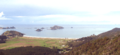
Panorama of Matauri Bay. The Cavalli Islands are further to the left.
-
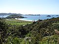
View over the bay


See also
 In Spanish: Bahía de Matauri para niños
