Cayo Batata facts for kids

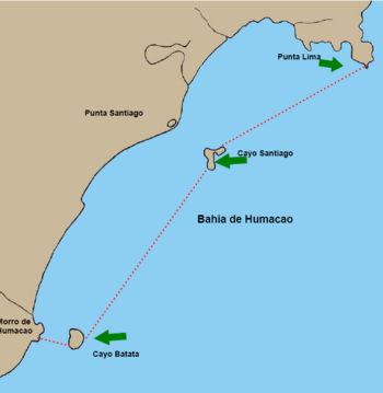
Map of Humacao Estuary with Cayo Batata in the southwest
|
|
| Geography | |
|---|---|
| Location | Humacao, Puerto Rico |
| Coordinates | 18°6′56″N 65°46′17″W / 18.11556°N 65.77139°W |
| Area | 4,679 m2 (50,360 sq ft) |
| Highest elevation | 12.1 m (39.7 ft) |
| Commonwealth | |
| Municipality | |
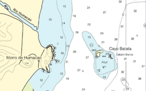
Cayo Batata is a small, uninhabited island. It is covered in grass. You can find it near Humacao, Puerto Rico. It's about 1,969 feet (or 600 meters) east of a place called Morro de Humacao. This spot is close to where the Río Humacao river meets the sea.
Exploring Cayo Batata's Location and Size
Cayo Batata is shaped like a rectangle. Its sides are between 197 and 230 feet long. The island is also quite high, reaching up to 39.7 feet (about 12 meters) above sea level.
The total area of Cayo Batata is about 50,364 square feet. This island is part of the Río Abajo area within the Humacao municipality.
Nearby Natural Features
East and south of Cayo Batata, there is a group of rocks and a reef. This area is known as Caballo Blanco, which means "White Horse." It's important not to confuse this spot with another islet of the same name near Vieques.
Another interesting island nearby is Cayo Santiago. It is also known as Monkey Island. Cayo Santiago is about 3.5 miles (or 5.6 kilometers) northeast of Cayo Batata. It is also part of Humacao.
See also
 In Spanish: Cayo Batata para niños
 | Kyle Baker |
 | Joseph Yoakum |
 | Laura Wheeler Waring |
 | Henry Ossawa Tanner |


