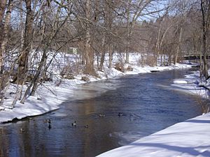
Cedar Creek (Wisconsin) facts for kids
Cedar Creek is a stream in southeastern Wisconsin, United States. It's about 53 kilometers (33 miles) long. The area that drains into Cedar Creek is called its watershed, and it covers about 330 square kilometers (127 square miles). This watershed is part of a larger one that feeds into the Milwaukee River.
Contents
Where Cedar Creek Flows
Cedar Creek starts at Big Cedar Lake near the Town of West Bend. From there, it flows east into Little Cedar Lake. It continues east through the village of Jackson. Then, it turns south and crosses State Highway 60. You can find a special gauge here that measures the water level.
The creek briefly goes through Grafton before reaching the north side of Cedarburg. It flows right through downtown Cedarburg. Finally, Cedar Creek empties into the Milwaukee River southeast of Cedarburg. The part of the creek that runs through Cedarburg has a steep slope. Long ago, early settlers used this fast-flowing water to power their mills.
Some parts of the creek, especially near downtown Cedarburg, have had pollution from old factories. But don't worry, many cleanups have happened to make the creek healthier. For example, a big cleanup was finished in 2018, clearing areas from the Cedarburg Mill's pond all the way to the Cedarburg Wire and Nail Factory dam.
Old Mills Along the Creek
In the past, many mills were built along the lower part of Cedar Creek. These mills used the creek's water power to run their machines. They were very important for the local economy.
Over time, mills started using steam or electric power instead of water. During the Great Depression and later, smaller mills found it hard to compete with bigger factories. By the late 1960s, all the mills had stopped working. Some of the old mill buildings are now used for shops or other businesses, while others were torn down.
| Mill Name | Year Built | What They Made | Notes |
|---|---|---|---|
| Concordia Mill | 1853 | Grain | Its dam was washed away in a flood in 1996. |
| Cedarburg Wire and Nail Factory | 1871 | Grain, lumber, steel, electricity | |
| Columbia Mill | 1843 | Grain | This mill was later torn down. |
| Cedarburg Mill | 1844 | Grain | It was rebuilt in 1855 with the stone building you see today. |
| Hilgen and Wittenberg Woolen Mill | 1864 | Textiles (like cloth) |
When the Creek Floods
Cedar Creek is usually a small, calm stream. However, like many rivers and creeks, it can flood sometimes. Flooding happens when there's too much rain or snowmelt, and the water overflows its banks.
In 1881, a sudden spring thaw caused a big flood. This flood washed away almost all the dams on Cedar Creek, except for the one at the Cedarburg Mill. It also destroyed at least one bridge. Other large floods happened in 1952, 1959, 1960, and 1975. In 1996, another flood washed out the dam at the Concordia Mill.
Parks Along Cedar Creek
Many public parks are located along Cedar Creek, offering places for people to enjoy nature and outdoor activities.
| Name | City/Town |
|---|---|
| Adlai Horn Park, Cedar Creek Park, Boy Scout Park | Cedarburg |
| Grafton Lions Park | Grafton |
| Covered Bridge Park, Town of Cedarburg Canoe Launch | Town of Cedarburg |
| Jackson Marsh State Natural Area | Jackson |
Bridges Over Cedar Creek
Many roads and railroads cross over Cedar Creek using bridges. Some of these bridges have interesting histories.
| Road/Railroad Name | How Many Times it Crosses | Notes |
|---|---|---|
| Green Bay Rd | 1 | |
| Lakefield Rd | 1 | This bridge was washed out in the big flood of 1881 but was rebuilt. |
| Canadian National Railroad | 4 | |
| Private | 1 | |
| Highland Avenue | 1 | The Highland Avenue Bridge was built in 1939 as a special project to create jobs. |
| Columbia Rd | 1 | |
| Bridge Rd | 1 | The original stone arches of this bridge are still visible, even though the top has been redone. |
| State Highway 60 | 5 | |
| Cedar Creek Rd | 3 | |
| County Highway I | 1 | |
| Covered Bridge Rd | 1 | This is where you can find the last covered bridge in the area. |
| Kaehlers Mill Rd | 1 | |
| County Highway NN | 2 | |
| County Highway Y | 1 | |
| County Highway M | 1 | |
| County Highway G | 1 | |
| Hickory Ln | 1 | |
| Sherman Rd | 2 | |
| Western Ave | 1 | |
| County Highway P | 1 | |
| Interstate 45 | 1 | |
| South Mayfield Rd | 1 | |
| Lily Rd | 2 | |
| Scenic Dr | 2 | |
| County Highway C | 1 | |
| Pleasant Valley Rd | 1 | |
| Hillside Rd | 1 |
 | Calvin Brent |
 | Walter T. Bailey |
 | Martha Cassell Thompson |
 | Alberta Jeannette Cassell |


