West Bend (town), Wisconsin facts for kids
Quick facts for kids
West Bend, Wisconsin
|
|
|---|---|

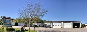
Town hall
|
|

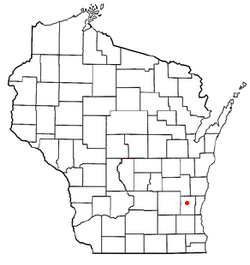
Location of West Bend (town), Wisconsin
|
|
| Country | |
| State | |
| County | Washington |
| Area | |
| • Total | 18.1 sq mi (47 km2) |
| • Land | 16.1 sq mi (41.8 km2) |
| • Water | 2 sq mi (5.2 km2) |
| Elevation | 1,093 ft (333 m) |
| Population
(2000)
|
|
| • Total | 4,834 |
| • Density | 299.5/sq mi (115.6/km2) |
| Time zone | UTC-6 (Central (CST)) |
| • Summer (DST) | UTC-5 (CDT) |
| Area code(s) | 262 |
| FIPS code | 55-85375 |
| GNIS feature ID | 1584400 |
West Bend is a town in Washington County, Wisconsin, in the United States. In 2000, about 4,834 people lived here. The larger City of West Bend is partly located within this town. A small community called Nabob is also part of the town.
Contents
History of West Bend
Early Inhabitants and Mound Builders
Long ago, the first people known to live in this area were called Mound Builders. They lived here between 650 and 1300 CE. These people were not farmers. They moved around to hunt, fish, and gather wild plants. They made tools from bone, wood, stone, and sometimes copper.
The Mound Builders created special mounds in the ground. Some were shaped like animals such as mammals, reptiles, and birds. Others were simple shapes like circles or lines. Some mounds were used to bury people. Many mounds in the West Bend area were destroyed by early settlers. But many still exist today. They are protected as part of the Washington County "Island" Effigy Mound District. This includes Lizard Mound County Park.
Native American Tribes
In the early 1800s, two Native American tribes lived in the West Bend area. These were the Potawatomi and Menominee Indians. In 1831, the Menominee gave up their land claims to the United States government. The Potawatomi did the same in 1833. They were asked to leave the area by 1838.
Many Native people moved west of the Mississippi River. But some Potawatomi stayed behind. They were sometimes called "strolling Potawatomi." They lived on their old lands, which were now owned by new settlers. There was a large Native American village on the shore of Silver Lake in the Town of West Bend. Later, the Potawatomi who stayed formed the Forest County Potawatomi Community in northern Wisconsin.
Founding the Town
In 1845, the Wisconsin government decided to build a road. This road would connect Fond du Lac and Milwaukee. They also planned a new settlement halfway between the two cities. This settlement would offer supplies and places to stay for travelers.
Three men, Byron Kilbourn, James Kneeland, and Erastus B. Wolcott, chose the location. They picked a spot on a westward bend in the Milwaukee River. This is where the City of West Bend is today. They chose this spot because the river could power mills. By 1845, they bought land along the river. In 1846, Wolcott built a dam and a sawmill. In 1848, he built a gristmill to grind grain.
The Wisconsin government officially created the Town of West Bend on January 20, 1846. At that time, the town was much larger. It included land that is now part of the City of West Bend. It also included parts of other towns like Barton and Farmington.
County Seat Changes
In the 1840s, Washington County was bigger than it is now. It included land that is now Ozaukee County, Wisconsin. Port Washington was the county seat. This means it was the main town for government business.
West Bend, Cedarburg, and Grafton all wanted to be the county seat. Being the county seat brought many benefits. In 1853, the government split Washington County into two parts. This created Ozaukee County. Port Washington became the seat of the new Ozaukee County. The Washington County seat then moved to the town of West Bend.
Growth and Development
A railroad station was built in West Bend in 1873. This brought new people and businesses to the community. The railroad also helped the town connect with other places. Because of its location on the river, its role as the county seat, and the new railroad, the City of West Bend grew quickly.
In March 1885, the City of West Bend officially became its own city. It separated from some of the town's land. After World War II, the City of West Bend grew even more. More people moved to the city and drove to work. New roads like U.S. Route 45 made it easier to travel to Milwaukee. Between 1950 and 1990, the city's population more than tripled. The city also took in more land from the Town of West Bend.
Geography
The town of West Bend covers about 18.1 square miles (47 square kilometers). Most of this area, about 16.1 square miles (41.8 square kilometers), is land. The rest, about 2 square miles (5.2 square kilometers), is water. This means about 11% of the town's area is water.
Population Information
In the year 2000, there were 4,834 people living in the town of West Bend. There were 1,611 households, which are groups of people living together. Most households, about 76%, were married couples.
The population was spread out by age:
- 24% were under 18 years old.
- About 25% were between 25 and 44 years old.
- About 19% were 65 years or older.
The average age in the town was 42 years.
See also
 In Spanish: West Bend (condado de Washington, Wisconsin) para niños
 | Kyle Baker |
 | Joseph Yoakum |
 | Laura Wheeler Waring |
 | Henry Ossawa Tanner |

