
West Bend, Wisconsin facts for kids
Quick facts for kids
West Bend, Wisconsin
|
||
|---|---|---|

Aerial view of downtown
|
||
|
||

Location of West Bend in Washington County, Wisconsin.
|
||

West Bend, Wisconsin
Location in Wisconsin

West Bend, Wisconsin
Location in the United States
|
||
| Country | ||
| State | ||
| County | Washington | |
| Settled | 1845 | |
| Incorporated | 1885 | |
| Area | ||
| • Total | 15.30 sq mi (39.62 km2) | |
| • Land | 15.14 sq mi (39.22 km2) | |
| • Water | 0.16 sq mi (0.40 km2) | |
| Elevation | 932 ft (284 m) | |
| Population
(2020)
|
||
| • Total | 31,752 | |
| • Density | 2,133.7/sq mi (805.46/km2) | |
| Time zone | UTC−6 (Central (CST)) | |
| • Summer (DST) | UTC−5 (CDT) | |
| ZIP Codes |
53090, 53095, 53096
|
|
| Area code(s) | 262 | |
| FIPS code | 55-85350 | |

West Bend is a city in Wisconsin, United States. It is the main city of Washington County, Wisconsin. In 2020, about 31,752 people lived there. West Bend is part of the larger Milwaukee metropolitan area.
Contents
History of West Bend
Early Settlers and Native Americans
Long ago, between 650 and 1300 CE, people called Mound Builders lived in this area. They built special earth mounds shaped like animals and other figures. These mounds were used for burials and ceremonies. Many mounds were destroyed by early settlers, but some still exist today. They are protected as the Washington County "Island" Effigy Mound District.
In the early 1800s, the Potawatomi and Menominee Native American tribes lived here. They gave up their land to the U.S. government in the 1830s. Many Native people moved west, but some stayed. They continued to live on their ancestral lands. Later, some Potawatomi formed the Forest County Potawatomi Community in northern Wisconsin.
How West Bend Began
The city of West Bend started in the mid-1840s. The Wisconsin government wanted a road built between Fond du Lac and Milwaukee. A new settlement was needed halfway for travelers to rest. This new place was built on a bend in the Milwaukee River. This bend gave the city its name: West Bend.
The river was important because it could power mills. In 1846, a dam and a sawmill were built. A gristmill followed in 1848. Another community, Barton, also grew nearby. It was named after Barton Salisbury, who built a sawmill there. Barton was once larger than West Bend.
Growth and Industry

In the 1890s, West Bend started to become an industrial city. Factories began to open. Some early companies made wagons and leather goods. The West Bend Aluminum Company started in 1911. It made affordable aluminum kitchen tools. Amity Leather, founded in 1915, became a very large maker of leather wallets.
Other companies made car parts and farm equipment. The Village of Barton grew too, but it later joined West Bend in 1961. During World War II, some local factories used people captured during the war to help with labor shortages.
After World War II, West Bend grew a lot. More people moved to the city. New roads like U.S. Route 45 made it easier to travel to Milwaukee for work. The city's population more than tripled between 1950 and 1990.
In 1981, a strong tornado hit West Bend. It caused damage and sadly, some people lost their lives. There is a monument in a park to remember this event.
Historic Places to Visit
The Washington County Historical Society runs several museums in West Bend. These include:
- The Old Courthouse Museum
- The Old Sheriff's Residence and Jail
- The West Bend Company/Regal Ware Museum
- Father Rehrl's Rectory at St. Agnes Historic Site
Downtown West Bend also has a movie theater called "The Bend." It first opened in 1929 and still shows movies and plays today.
Geography and Climate
West Bend covers about 14.72 square miles (38.12 square kilometers). Most of this area is land, with a small amount of water.
The city is in the Kettle Moraine area. This region has many hills and hollows. These were formed by glaciers long ago.
Weather in West Bend
West Bend has a range of temperatures. The average high in July is 81°F (27°C). The average low in January is 11°F (-12°C). The highest temperature ever recorded was 107°F (42°C). The lowest was -30°F (-34°C).
The city gets about 31.4 inches (80 cm) of rain each year. It also gets about 45.6 inches (116 cm) of snow annually.
Population and People
West Bend has grown steadily over the years. In 1870, there were just over 1,000 people. By 2020, the population was 31,752.
Most people in West Bend are White. There are also smaller groups of African American, Asian, and Native American residents. About 3.9% of the population is Hispanic or Latino.
The average age in West Bend is 37 years old. About 24.7% of residents are under 18. Many households have children living with them.
Economy and Jobs
West Bend has a history of manufacturing and financial services. Many people who live in West Bend also work in nearby towns.
West Bend Mutual Insurance Company started here in 1894. West Bend Savings Bank opened in 1926. The West Bend Company, which made kitchenware, was founded in 1911. Another company, B.C. Ziegler, started in 1902 and helps with investments.
Amity Leather, a large leather goods maker, was founded in West Bend in 1915. It left the city in 1996. During the 1930s, West Bend's economy was so strong that some people said it avoided the Great Depression. The printing company Serigraph, Inc. and the Gehl Company, which makes equipment, are also based here.
Military Presence
The Army National Guard has an armory in West Bend. It is located near the airport.
Fun Things to Do in West Bend
West Bend has many ways to enjoy the outdoors and have fun.
Parks and Trails
A paved riverwalk runs along the Milwaukee River. The Eisenbahn State Trail is a path for walking, running, biking, and roller skating. The famous 1,000-mile National Ice Age Trail also goes through West Bend. The city has over 1,200 acres of parks and green spaces.
- Regner Park: This park is north of downtown. It has woods for hiking, a baseball field, a swimming pond with a beach, and fields for softball and soccer.
- Quaas Creek Park: On the southeast side, this park has bike trails, a place to launch canoes, softball fields, and a playground.
- Lac Lawrann Conservancy: This nature preserve has 137 acres and 5 miles of trails.
Events and Activities
- Farmers' Market: A large farmers' market is held downtown on Saturday mornings from May to October. It has over 65 vendors selling food and crafts.
- Music on Main: On summer Thursday nights, a street downtown closes for live music at Old Settler's Park.
- Summer Festivals: Events like Maxwell Street Days, German Fest, and Riverfest (formerly Seafood Fest) are held in the summer. JazzFest is another annual event.
- Geocaching Capital: West Bend is known as the "Geocaching Capital of the Midwest™." There are over 1,200 geocaches nearby. An annual "Cache Ba$h" event is held here.
- Enchantment in the Park: During the holidays, Regner Park hosts a light show. Visitors can also see Santa and go ice skating.
- Museum of Wisconsin Art: This museum shows art created by Wisconsin artists.
- Washington County Fair Park: Located south of the city, this center hosts many events, including the Washington County Fair.
Education in West Bend
The West Bend School District serves the city. It has six elementary schools, two middle schools, and two high schools.
The two high schools, West Bend East and West Bend West, are in the same building. They share facilities but are separate schools with their own sports teams. The middle schools are Silverbrook Intermediate School and Badger Middle School.
Rolf's Educational Center offers programs like Head Start for young children. The district also has an online learning academy. For higher education, students can attend University of Wisconsin-Milwaukee at Washington County (UWM-WC) or Moraine Park Technical College.
There are also several private schools in West Bend. These include Lutheran schools like Good Shepherd, Trinity, and St. John's. There are also Roman Catholic schools like St. Frances Cabrini and Holy Angels.
Media and News
West Bend has its own radio stations. WMBZ (92.5 FM) plays country music, and WRYU (1470 AM) plays classic rock. The city's official newspaper is the West Bend Daily News.
The West Bend Booster was another local newspaper, but it closed in 2020. The city and school district also have their own TV channels. These channels are available on cable and online.
Getting Around West Bend
Transportation Options
- Airport: The West Bend Municipal Airport is a public airport east of the city.
- Public Transit: West Bend has city and county taxi programs. A bus service to Milwaukee used to run but ended in 2023.
- Highways: Major roads serving West Bend include US 45, Wis 33, and Wis 144.
- Rail: A Union Pacific train line serves West Bend, connecting it to Milwaukee.
Famous People from West Bend
Many notable people have come from West Bend, including:
- William Arnemann, a state representative
- Zack Baun, a football player
- Ward Christensen, a computer scientist
- John DeMerit, a baseball player
- Almah Jane Frisby, a physician and professor
- Ryan Rohlinger, a baseball player
- Jordan Stolz, a World Champion speed skater
- Morgan White, a gymnast
Sister Cities
West Bend has friendly relationships with cities in other countries:
 Aisho, Japan
 Heppenheim, Germany
 Pazardzhik, Bulgaria
Images for kids
-
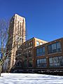
The Amity Leather Products factory was built in 1925. It is a historic building in West Bend.
See also
 In Spanish: West Bend (Wisconsin) para niños
