Chagai District facts for kids
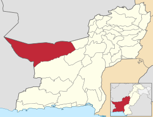
Chagai is the biggest district in Pakistan. It's located in the northwest part of Balochistan, which is a large province in Pakistan. This district shares a special border that touches three countries: Pakistan, Afghanistan, and Iran. Imagine a triangle where Chagai is at the corner!
Contents
Chagai District: Pakistan's Largest Area
Chagai is known for being the largest district in all of Pakistan. Its huge size means it covers a lot of land in the Balochistan province. This area is very important because of where it is located.
Where is Chagai Located?
Chagai sits in the northwest corner of Balochistan. This part of Pakistan is known for its wide-open spaces and unique landscapes. The district's location is special because it forms a border with two other countries.
Chagai's International Borders
Chagai shares a border with both Afghanistan and Iran. This means it's a place where three countries meet! This kind of border is called an "internationalized border" because it's a meeting point for different nations. It's like a natural bridge connecting Pakistan with its neighbors.
How Chagai is Managed
Even though Chagai is very large, it is divided into smaller areas to help manage everything. These smaller parts are called "tehsils." Think of a tehsil as a local administrative area, like a county or a borough.
Administrative Divisions of Chagai
The Chagai District is split into several tehsils. Each tehsil helps with local government and services for the people living there. The tehsils in Chagai are:
- Chagai Tehsil
- Dak Tehsil
- Nokundi Tehsil
- Saindak Tehsil
- Taftan Tehsil
 | Toni Morrison |
 | Barack Obama |
 | Martin Luther King Jr. |
 | Ralph Bunche |


