Cheltenham Badlands facts for kids
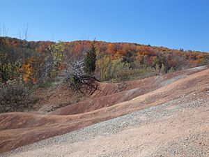
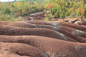
The Cheltenham Badlands are a unique natural area in Caledon, Ontario. You can find them on the southeast side of Olde Base Line Road. This special place covers about 0.4 square kilometers. It shows off exposed and highly eroded red rock called Queenston shale. The Cheltenham Badlands are important for learning about how the Earth changes. Their bright red color and unusual hills make them a popular spot for visitors. This site is a Provincial Earth Sciences Area of Natural and Scientific Interest (ANSI). It's considered one of the best examples of "badlands topography" in Ontario.
Contents
What are the Badlands?
The Cheltenham Badlands are also known by other names like the Red Clay Hills. They are located about 3.8 kilometers west of Highway 10. The northern edge of the badlands is Olde Base Line Road. The entire property is 36.6 hectares, but the exposed badlands part is about 0.4 square kilometers.
These Badlands are part of the Niagara Escarpment. This Escarpment was named a UNESCO World Biosphere Reserve in 1990. This means it's a very special natural area recognized globally. The badlands act like a natural border between wild parts of the Escarpment and more developed areas. They are also considered an Escarpment Access Park. The main path of the Bruce Trail system crosses through the site. This trail is a great place for hiking.
The Cheltenham Badlands are also a designated Earth Sciences Area of Natural Scientific Interest. This means they are protected for their geological importance. They are also part of an important area where groundwater comes to the surface. This area is called the Inglewood Slope Environmentally Sensitive Area. A cold-water stream flows at the bottom of the badlands. This stream is a small branch of the Credit River, which eventually flows into Lake Ontario.
How the Badlands Formed
The Badlands show an exposed section of rock called the Queenston Formation. This rock formed a very long time ago, between 420 and 415 million years ago. This was during the Middle and Late Ordovician periods. Back then, two huge landmasses, Gondwana and Laurentia, collided. This collision created the Taconic Mountains.
Over millions of years, these mountains slowly wore down. The eroded mud and sand flowed into ancient basins, forming what is called the Queenston Delta. This mud settled and hardened into the Queenston Shale. As the mountains continued to erode, less mud reached the delta. This led to layers of sandstone, shale, and limestone forming on top of the Queenston Shale. At the badlands site, glaciers later scraped away these top layers. This left the Queenston Formation as the first layer of rock under the soil.
Queenston Rock
The Queenston Formation is famous for its brick-red to maroon colored shale. It also has smaller amounts of green shale, sandstone, and limestone mixed in. The dark red color comes from muddy deposits that settled in the ancient delta. The shale layers are thin and easily broken.
The distinct red color of these rocks is due to iron-oxide, like rust. Sometimes you see green-grey bands in the rock. Scientists think these bands are caused by changes in how water moves through the rock. This can change the rock's color.
The clay in the Queenston shale is mostly made of minerals called illite and chlorite. These minerals don't swell much when wet. However, repeated wetting and drying can cause the shale to break apart. This process helps create the unique eroded shapes of the badlands.
Changes to the Land
Land Use History
In the late 1800s and early 1900s, the Cheltenham Badlands property was used for farming. Farmers mostly grazed cattle there. Farming stopped in 1931, and nature began to reclaim most of the land.
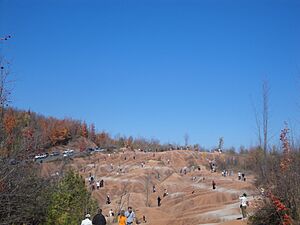
Once erosion starts in this type of soil, it can happen very quickly. This is especially true if people clear land, let animals over-graze, or walk on the fragile ground too much. The shale itself is very easy to erode. The main part of the Badlands has no plants because so many people walk there in warmer months. However, less visited areas, like the northwest side, have more plants growing.
A part of the main Bruce Trail has been on the property since 1989. A side trail, called the Russell Cooper side trail, used to connect to a viewing area. This side trail was closed from 2001 to 2007 because of concerns about erosion and maintenance.
How the Land Changes
The Cheltenham Badlands offer a great chance to see the Queenston Formation. You can also observe how land wears away and changes over time. The badlands are mostly red shale that has been eroded into smooth gullies and hills.
The bumpy channels and gullies you see are formed by temporary streams. These streams carry meltwater and stormwater from higher areas down to the stream below. These channels are important features in clay-rich badlands. Also, the clay near the surface expands and shrinks. This happens as moisture and temperature change, leading to even more erosion.
Studies show that between 1973 and 2009, the badlands eroded by up to 3.2 meters in some spots. On average, the land wears away by about 0.7 to 2.5 centimeters each year. The upper parts of the site have steeper slopes. This is because eroded material from higher up gets deposited in the lower areas. The gullies in the lower parts have become more stable over time.
Protecting the Badlands
Ownership History
The Cheltenham Badlands property has had several owners over the years. George Wilson owned it from 1870 to 1877. Later, Russell Cooper bought the property in 1929. The Cooper family owned it until 1989. In 1999, the property was listed for purchase under a Natural Areas Protection Program.
In 2000, the Ontario Ministry of Natural Resources bought the property for $500,000. It became part of the Niagara Escarpment Parks and Open Spaces System. Ownership was then transferred to the Ontario Heritage Trust in 2002. The Bruce Trail Conservancy and the Credit Valley Conservation Authority became responsible for managing the site.
Badlands Protection Efforts
To help manage the site, a study was done between 2009 and 2010. This study looked at how the badlands were eroding. It found two main things:
- Walking on the soil does not reduce erosion.
- Human foot traffic might cause up to 10% of the annual soil loss.
Other concerns for managing the site included:
- Safety issues on the road due to many parked cars and visitors.
- Garbage and littering.
- Damage to trail signs and structures.
- People creating new, unofficial trails.
- The general impact of people, horses, and bikes on the badlands slopes.
Because of too many visitors walking on the fragile formations, the site was closed on May 6, 2015. This was done to prevent more damage and speed up erosion. In July 2015, fences were put up, and "no trespassing" signs were added. Parking areas were changed to "no-parking" zones. The closure was meant to be temporary while a plan was developed.
The good news is that the area re-opened on September 22, 2018! The newly opened site now has an accessible boardwalk. There's also a new starting point for trails and clear signs. A new parking area helps manage traffic and provides safe access. Educational signs were also added as part of a project that started in 2017. These changes help protect the badlands while still allowing people to visit and learn.
 | Isaac Myers |
 | D. Hamilton Jackson |
 | A. Philip Randolph |


