
Chester Borough, New Jersey facts for kids
Quick facts for kids
Chester Borough, New Jersey
|
||
|---|---|---|
|
Borough
|
||

Main Street in Downtown Chester
|
||
|
||

Location of Chester Borough in Morris County highlighted in red (right). Inset map: Location of Morris County in New Jersey highlighted in orange (left).
|
||

Census Bureau map of Chester Borough, New Jersey
|
||

Chester Borough, New Jersey
Location in Morris County, New Jersey

Chester Borough, New Jersey
Location in New Jersey

Chester Borough, New Jersey
Location in the United States
|
||
| Country | ||
| State | ||
| County | ||
| Incorporated | April 3, 1930 | |
| Named for | Chestershire, England | |
| Government | ||
| • Type | Borough | |
| • Body | Borough Council | |
| Area | ||
| • Total | 1.59 sq mi (4.13 km2) | |
| • Land | 1.59 sq mi (4.12 km2) | |
| • Water | 0.00 sq mi (0.00 km2) 0.13% | |
| Area rank | 441st of 565 in state 37th of 39 in county |
|
| Elevation | 866 ft (264 m) | |
| Population
(2020)
|
||
| • Total | 1,681 | |
| • Estimate
(2023)
|
1,678 | |
| • Rank | 503rd of 565 in state 38th of 39 in county |
|
| • Density | 1,055.7/sq mi (407.6/km2) | |
| • Density rank | 376th of 565 in state 28th of 39 in county |
|
| Time zone | UTC−05:00 (Eastern (EST)) | |
| • Summer (DST) | UTC−04:00 (Eastern (EDT)) | |
| ZIP Code |
07930
|
|
| Area code(s) | 908 | |
| FIPS code | 3402712580 | |
| GNIS feature ID | 0885184 | |

Chester Borough is a small town, called a borough, located in southwestern Morris County, in the state of New Jersey. In 2020, about 1,681 people lived here. The borough's name comes from Chestershire in England.
Chester Borough is special because it's completely surrounded by Chester Township. This makes it one of 21 "doughnut towns" in New Jersey, where one town is entirely inside another!
Contents
History of Chester Borough
Chester Borough has an interesting past. It officially became its own town on April 3, 1930. Before that, it was part of Chester Township, which was formed way back in 1799. The name "Chester" was chosen because it reminded early settlers of Chestershire, a place in England.
Geography and Location
Chester Borough covers about 1.59 square miles (4.13 square kilometers) of land. There's hardly any water within its borders. As mentioned, it's entirely surrounded by Chester Township. Imagine a doughnut: Chester Borough is the hole, and Chester Township is the doughnut itself!
Population and People
| Historical population | |||
|---|---|---|---|
| Census | Pop. | %± | |
| 1880 | 705 | — | |
| 1890 | 683 | −3.1% | |
| 1940 | 650 | — | |
| 1950 | 754 | 16.0% | |
| 1960 | 1,074 | 42.4% | |
| 1970 | 1,299 | 20.9% | |
| 1980 | 1,433 | 10.3% | |
| 1990 | 1,214 | −15.3% | |
| 2000 | 1,635 | 34.7% | |
| 2010 | 1,649 | 0.9% | |
| 2020 | 1,681 | 1.9% | |
| 2023 (est.) | 1,678 | 1.8% | |
| Population sources: 1880–1890 1940–1990 2000 2010 2020 |
|||
In 2010, there were 1,649 people living in Chester Borough. The population has grown a little over the years. Most people living here are White, but there are also Black, Asian, and Native American residents. About 13.5% of the population identified as Hispanic or Latino. The average age in Chester Borough in 2010 was about 43 years old.
Fun in Chester Borough

Chester is known for its beautiful natural surroundings. It was even named one of the top ten most beautiful towns in New Jersey in 2016! You'll find many dense forests and hiking trails around the town.
There are several great parks for outdoor activities:
- Hacklebarney State Park
- Black River County Park, which has the famous Nathan Cooper Gristmill. These parks are perfect for family hikes, especially in the fall when the leaves change color.
- Willowwood Arboretum is another fantastic spot. It has 131 acres of gardens, meadows, and walking trails.
Places of Worship
Chester Borough is home to several historic churches:
- The First Congregational Church on Hillside Road has been active since 1740. This old church building is listed on the National Register of Historic Places. It's the oldest Congregational church west of the Hudson River.
- Grace Bible Chapel is a non-denominational Christian church.
- St. Lawrence the Martyr Roman Catholic Church was formed in the mid-1950s and has about 1,200 families.


Schools in Chester Borough
Students in Chester Borough attend public schools through the Chester School District. This district also serves children from Chester Township. The district has three schools:
- Dickerson Elementary School (Pre-K to 2nd grade)
- Bragg Elementary School (3rd to 5th grade)
- Black River Middle School (6th to 8th grade)
For high school, students go to West Morris Mendham High School. This school is part of the West Morris Regional High School District. It serves students from Chester Borough, Chester Township, Mendham Borough, and Mendham Township.
Getting Around Chester
_in_Chester,_Morris_County,_New_Jersey.jpg)
Chester Borough has about 12 miles of roads. The main roads that meet in Chester are County Route 513 and U.S. Route 206.
Public bus service used to be available through NJ Transit on the MCM4 and MCM5 routes, but this service ended in June 2010.
Places to See
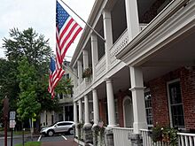
- The Chester House Inn is a historic building located at the corner of Main Street and Hillside Road. It is also listed on the National Register of Historic Places.
-

Chester House Inn
-
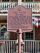
Brick Tavern listed on the NRHP
-
Chester Publick House


Famous People from Chester Borough
Many interesting people have connections to Chester Borough:
- Lois Barker (1923–2018) was a baseball player in the All-American Girls Professional Baseball League.
- Alex Cable is an inventor who started a company called Thorlabs in Chester.
- Lester H. Clee (1888–1962) was a politician who served as the mayor of Chester.
- Matt Flanagan (born 1995) is a professional football player.
- Fran Hopper (1922–2017) was one of the first women comic book artists during the Golden Age of Comic Books.
- Larry W. Maysey (1946–1967) was an Air Force Pararescueman who received a special award for bravery.
- Jared Stroud (born 1996) is a professional soccer player.
See also
 In Spanish: Chester (Nueva Jersey) para niños
