Chigorodó facts for kids
Quick facts for kids
Chigorodó
|
|||
|---|---|---|---|
|
Municipality and town
|
|||
|
|||

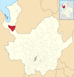
Location of the municipality and town of Chigorodó in the Antioquia Department of Colombia
|
|||
| Country | |||
| Department | |||
| Subregion | Urabá | ||
| Founded | 1878 | ||
| Area | |||
| • Municipality and town | 608 km2 (235 sq mi) | ||
| • Urban | 3.56 km2 (1.37 sq mi) | ||
| Elevation | 34 m (112 ft) | ||
| Population
(2020 est.)
|
|||
| • Municipality and town | 86,239 | ||
| • Density | 141.84/km2 (367.37/sq mi) | ||
| • Urban | 50,581 | ||
| • Urban density | 14,208/km2 (36,800/sq mi) | ||
| Demonym(s) | Chigorodoseños | ||
| Time zone | UTC-5 (Colombia Standard Time) | ||
| Area code(s) | 57 + 4 | ||
| Website | Official website: http://chigorodo-antioquia.gov.co/ | ||
Chigorodó is a vibrant town and municipality in Colombia. It is located in the Antioquia Department, which is a part of the Urabá Antioquia region. The town was founded in 1878.
Chigorodó is home to over 86,000 people. Those who live here are called Chigorodoseños. The town covers an area of about 608 square kilometers.
Who Lives in Chigorodó?
Many interesting people call Chigorodó home. One famous person from here is:
- Jaime Castañeda: He is a well-known cyclist.
What's the Weather Like in Chigorodó?
Chigorodó has a tropical rainforest climate. This means it is warm all year round. It also gets a lot of rain. The rain can be very heavy at times.
The weather box below shows more details about the climate. It includes average temperatures and how much rain falls each month.
| Climate data for Chigorodó (Palmera La), elevation 58 m (190 ft), (1981–2010) | |||||||||||||
|---|---|---|---|---|---|---|---|---|---|---|---|---|---|
| Month | Jan | Feb | Mar | Apr | May | Jun | Jul | Aug | Sep | Oct | Nov | Dec | Year |
| Mean daily maximum °C (°F) | 31.2 (88.2) |
31.7 (89.1) |
32.0 (89.6) |
31.4 (88.5) |
31.3 (88.3) |
31.1 (88.0) |
31.0 (87.8) |
31.0 (87.8) |
31.0 (87.8) |
30.9 (87.6) |
30.5 (86.9) |
30.7 (87.3) |
31.2 (88.2) |
| Daily mean °C (°F) | 27.2 (81.0) |
27.7 (81.9) |
27.8 (82.0) |
27.6 (81.7) |
27.4 (81.3) |
27.3 (81.1) |
27.1 (80.8) |
27.2 (81.0) |
27.1 (80.8) |
27.1 (80.8) |
27.0 (80.6) |
27.0 (80.6) |
27.3 (81.1) |
| Mean daily minimum °C (°F) | 22.3 (72.1) |
22.2 (72.0) |
22.9 (73.2) |
22.9 (73.2) |
22.9 (73.2) |
22.7 (72.9) |
22.4 (72.3) |
22.4 (72.3) |
22.1 (71.8) |
22.2 (72.0) |
22.4 (72.3) |
22.6 (72.7) |
22.5 (72.5) |
| Average precipitation mm (inches) | 142.2 (5.60) |
87.5 (3.44) |
120.6 (4.75) |
270.7 (10.66) |
427.9 (16.85) |
449.2 (17.69) |
396.5 (15.61) |
414.3 (16.31) |
443.6 (17.46) |
455.1 (17.92) |
363.2 (14.30) |
313.9 (12.36) |
3,803.9 (149.76) |
| Average precipitation days (≥ 1.0 mm) | 9 | 7 | 9 | 16 | 20 | 23 | 24 | 23 | 23 | 23 | 21 | 16 | 201 |
| Average relative humidity (%) | 81 | 78 | 78 | 82 | 83 | 83 | 83 | 84 | 84 | 84 | 83 | 84 | 82 |
| Mean monthly sunshine hours | 105.4 | 107.3 | 65.1 | 81.0 | 74.4 | 75.0 | 80.6 | 96.1 | 81.0 | 105.4 | 90.0 | 86.8 | 1,048.1 |
| Mean daily sunshine hours | 3.4 | 3.8 | 2.1 | 2.7 | 2.4 | 2.5 | 2.6 | 3.1 | 2.7 | 3.4 | 3.0 | 2.8 | 2.9 |
| Source: Instituto de Hidrologia Meteorologia y Estudios Ambientales | |||||||||||||
See also
 In Spanish: Chigorodó para niños
Black History Month on Kiddle
Famous African-American Athletes:
 | Jackie Robinson |
 | Jack Johnson |
 | Althea Gibson |
 | Arthur Ashe |
 | Muhammad Ali |

All content from Kiddle encyclopedia articles (including the article images and facts) can be freely used under Attribution-ShareAlike license, unless stated otherwise. Cite this article:
Chigorodó Facts for Kids. Kiddle Encyclopedia.


