Chiriguaná facts for kids
Quick facts for kids
Chiriguaná
|
|||
|---|---|---|---|

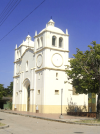
Chiriguana church
|
|||
|
|||

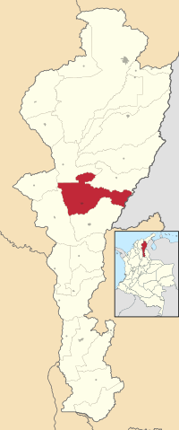
Location of the municipality and town of Chiriguaná in the Department of Cesar.
|
|||
| Country | Colombia | ||
| Region | Caribbean | ||
| Department | Cesar | ||
| Area | |||
| • Total | 1,103 km2 (426 sq mi) | ||
| Population
(Census 2018)
|
|||
| • Total | 27,006 | ||
| Time zone | UTC-5 | ||
| Website | www.chiriguana-cesar.gov.co/ |
||
Chiriguaná is a town and a "municipality" in Colombia. A municipality is like a local government area. It is located in the Department of Cesar, which is one of the many regions in Colombia. Chiriguaná is known for its warm, tropical climate and its interesting history.
Contents
History of Chiriguaná
Fighting for Independence
Chiriguaná played a part in Colombia's fight to become independent from Spain. This happened during the early 1800s. At that time, Chiriguaná was part of the Province of Santa Marta.
The people of Chiriguaná were brave. They decided to stand up against the Spanish rulers. They wanted their own freedom.
Local Leaders and the Cause
The local council, called the Cabildo (which was like a town government), was very active. The Cabildo of Justice and Regiment in Chiriguaná showed their support for independence. They worked with other towns, like Valledupar.
Important members of the Cabildo included Jose Pio del Rio and Braulio de Leiva. These leaders and others helped push for the independence movement. This movement had started in 1810 with the first big protest against Spanish rule.
Climate in Chiriguaná
Chiriguaná has a tropical savanna climate. This means it's warm all year round. You won't find cold winters here!
Wet and Dry Seasons
The year is divided into two main parts. There is a wet season from April to November. During these months, Chiriguaná gets a lot of rain. The dry season is from December to March. This is when the weather is much drier.
| Climate data for Chiriguaná, elevation 40 m (130 ft), (1981–2010) | |||||||||||||
|---|---|---|---|---|---|---|---|---|---|---|---|---|---|
| Month | Jan | Feb | Mar | Apr | May | Jun | Jul | Aug | Sep | Oct | Nov | Dec | Year |
| Mean daily maximum °C (°F) | 35.0 (95.0) |
36.0 (96.8) |
35.5 (95.9) |
34.0 (93.2) |
32.9 (91.2) |
32.8 (91.0) |
33.6 (92.5) |
33.8 (92.8) |
32.5 (90.5) |
31.9 (89.4) |
32.2 (90.0) |
33.4 (92.1) |
33.6 (92.5) |
| Daily mean °C (°F) | 28.6 (83.5) |
29.1 (84.4) |
29.1 (84.4) |
28.7 (83.7) |
28.1 (82.6) |
28.2 (82.8) |
28.5 (83.3) |
28.5 (83.3) |
27.9 (82.2) |
27.6 (81.7) |
27.7 (81.9) |
28.1 (82.6) |
28.4 (83.1) |
| Mean daily minimum °C (°F) | 21.2 (70.2) |
21.5 (70.7) |
21.8 (71.2) |
22.1 (71.8) |
22.0 (71.6) |
22.3 (72.1) |
22.4 (72.3) |
22.2 (72.0) |
21.9 (71.4) |
21.9 (71.4) |
21.9 (71.4) |
21.7 (71.1) |
21.9 (71.4) |
| Average precipitation mm (inches) | 16.3 (0.64) |
31.4 (1.24) |
73.0 (2.87) |
191.8 (7.55) |
263.6 (10.38) |
178.0 (7.01) |
167.5 (6.59) |
201.2 (7.92) |
309.4 (12.18) |
342.5 (13.48) |
221.6 (8.72) |
57.6 (2.27) |
2,053.8 (80.86) |
| Average precipitation days | 1 | 2 | 4 | 8 | 10 | 7 | 7 | 9 | 11 | 11 | 8 | 3 | 81 |
| Average relative humidity (%) | 72 | 71 | 73 | 78 | 81 | 82 | 79 | 79 | 83 | 84 | 83 | 79 | 79 |
| Mean monthly sunshine hours | 272.8 | 234.3 | 213.9 | 192.0 | 182.9 | 201.0 | 226.3 | 223.2 | 186.0 | 189.1 | 201.0 | 244.9 | 2,567.4 |
| Mean daily sunshine hours | 8.8 | 8.3 | 6.9 | 6.4 | 5.9 | 6.7 | 7.3 | 7.2 | 6.2 | 6.1 | 6.7 | 7.9 | 7.0 |
| Source: Instituto de Hidrologia Meteorologia y Estudios Ambientales | |||||||||||||
See also
 In Spanish: Chiriguaná para niños
 | Frances Mary Albrier |
 | Whitney Young |
 | Muhammad Ali |


