Chiselbury facts for kids

Chiselbury
|
|
| Location | Wiltshire |
|---|---|
| Coordinates | 51°03′08″N 1°58′33″W / 51.0522°N 1.9757°W |
| Area | 10.5 acres |
| History | |
| Periods | Iron Age |
| Site notes | |
| Public access | yes |
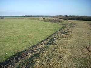
Chiselbury is an ancient site in Wiltshire, England. It was once an Iron Age hillfort, which is like a fortified village built on a hill. This hillfort is shaped almost like a circle. It covers an area of about 10.5 acres, which is roughly the size of eight football fields.
The fort was protected by a large earth wall, called a rampart, which was up to 3.6 meters (about 12 feet) tall. Outside this wall was a deep ditch, up to 1.6 meters (about 5 feet) deep. There was a special opening on the southeast side of the rampart. This opening, with a path across the ditch, was likely the main entrance to the fort. Near the entrance, there was a small, D-shaped area with its own earth walls. Even though farming has flattened it over time, you can still see parts of it today.
Contents
What Did They Find at Chiselbury?
Archaeologists looked inside the hillfort a long time ago, in the early 1900s. They didn't find clear signs that people lived right inside the fort. However, outside the fort, they found some pieces of Iron Age pottery. They also found a lead spindle whorl, which is a small weight used for spinning thread.
Later, two Roman coins were found in the middle of the fort. One of these coins was from the time of Emperor Constantine I. This shows that people might have used the area even after the Iron Age. An Iron Age sword and its scabbard (the case for the sword) were also found nearby. They were discovered on a track that runs along the top of the ridge.
Mysterious Ditches Around the Fort
On both the north and south sides of the hillfort, there are long ditches with earth banks. These are called cross dykes. We don't know exactly what they were for. But because they cut across the ridge, they might have been built to control movement along it.
- The Northern Cross Dyke: This ditch was about 90 meters (295 feet) long. It started at the hillfort's ditch and went across the ridge. It then continued partway down the northern slope. In 1928, you could see it clearly. But farming has since filled in the part near the hillfort. It still exists underground, though.
- The Southern Cross Dyke: This one is about 180 meters (590 feet) long. It's not a continuous ditch, but a series of banks and ditches. Some parts are filled in but are still buried. It runs from the D-shaped enclosure down the southern side of the ridge into a valley.
The Ancient Trackway
An old photograph from 1928 shows that the southern cross dyke continues underground beneath a trackway. This means the trackway was built after the cross dyke. An old Anglo-Saxon document also mentions "the ridgeway." This suggests the trackway was in use by the early medieval period (around 500-1500 AD).
In 1776, a doctor named Stukeley called it the 'Ten Mile Course'. During the medieval and post-medieval times, this trackway was the main road between Wilton and Shaftesbury. By the 1700s, it became a turnpike road. This means people had to pay a toll to use it. A map from 1773 shows a toll house right next to it. Today, you can still see the remains of this toll house as low earth mounds.
Chiselbury is an important historical site. It is protected as a national monument (number 1020262).
Today, Chiselbury is also famous for the Fovant Badges. These are huge pictures of regimental badges carved into the chalk of the hill's northern side. Soldiers created them during the First World War. You can see them clearly from the A30 road that goes through the village of Fovant.
Location of Chiselbury
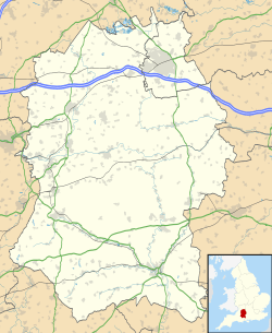
The Chiselbury hillfort is located southeast of the small village of Fovant in Wiltshire. The top of the hill is 201 meters (about 660 feet) above sea level. There are public footpaths and bridleways (paths for horses) to the east and south of the site.
Images for kids


