
Churchtown, Pennsylvania facts for kids
Quick facts for kids
Churchtown, Pennsylvania
|
|
|---|---|

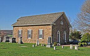
Bangor Episcopal Church
|
|

Churchtown, Pennsylvania
Location in Pennsylvania

Churchtown, Pennsylvania
Location in the United States
|
|
| Country | United States |
| State | Pennsylvania |
| County | Lancaster |
| Township | Caernarvon |
| Area | |
| • Total | 1.90 sq mi (4.92 km2) |
| • Land | 1.89 sq mi (4.88 km2) |
| • Water | 0.01 sq mi (0.04 km2) |
| Elevation | 564 ft (172 m) |
| Population
(2020)
|
|
| • Total | 417 |
| • Density | 221.22/sq mi (85.43/km2) |
| Time zone | UTC-5 (Eastern (EST)) |
| • Summer (DST) | UTC-4 (EDT) |
| ZIP code |
17555
|
| Area code(s) | 717 |
| FIPS code | 42-13632 |
| GNIS feature ID | 1171873 |
Churchtown is a small community in Lancaster County, Pennsylvania, United States. It is known as an unincorporated community, which means it doesn't have its own local government like a city or town. It is also a census-designated place (CDP), which is an area the U.S. Census Bureau defines for gathering population data.
Churchtown is located within Caernarvon Township, Lancaster County, Pennsylvania. In 2010, about 470 people lived here.
History of Churchtown
Churchtown has a special place in history. It is near where the very first Amish settlers made their homes. This was the start of the Lancaster Amish settlement, which is still active today.
Several buildings in Churchtown are very old and important. They are listed on the National Register of Historic Places. This means they are protected because of their historical value. These include:
- The Bangor Episcopal Church
- The Caernarvon Presbyterian Church
- The Edward Davies House
Geography and Location
Churchtown is in the eastern part of Lancaster County, Pennsylvania. It sits right in the middle of Caernarvon Township.
The main road through the community is Pennsylvania Route 23. This road is like the main street of Churchtown. If you travel east on Route 23, you will reach Morgantown in about 4 miles. If you go west, you will arrive in Lancaster, the county seat, which is about 20 miles away.
Churchtown covers an area of about 1.9 square miles (4.9 square kilometers). Most of this area is land, with only a small part being water. The community is on a ridge, which is a raised strip of land. Water from this ridge flows south into the Conestoga River. The Conestoga River then flows west and joins the larger Susquehanna River.
-
Caernarvon Presbyterian Church
-
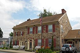
Edward Davies House, also known as the Churchtown Inn


Population Information
The U.S. Census Bureau collects information about how many people live in places like Churchtown. This is called demographics.
| Historical population | |||
|---|---|---|---|
| Census | Pop. | %± | |
| 2020 | 417 | — | |
| U.S. Decennial Census | |||
In 2020, the population of Churchtown was 417 people.
See also
 In Spanish: Churchtown (Pensilvania) para niños
