
Chutixtiox facts for kids

Shrine on the main plaza at Chutixtiox
|
|
| Alternative name | Xutixtiox, Chu'Taxtyoox |
|---|---|
| Location | Sacapulas |
| Region | Quiché Department, Guatemala |
| Coordinates | 15°16′28.2″N 91°7′21.72″W / 15.274500°N 91.1227000°W |
| History | |
| Periods | Postclassic |
| Cultures | Maya civilization |
| Site notes | |
| Excavation dates | 1955 |
| Archaeologists | A. Ledyard Smith |
| Architecture | |
| Architectural styles | Postclassic Maya |
| Responsible body: IDAEH | |
Chutixtiox (also called Xutixtiox or Chu'Taxtyoox) is an ancient Maya city. It is located near Sacapulas in the Quiché Department of modern Guatemala. This important site was explored by archaeologist A. Ledyard Smith in the 1900s.
Scientists found pottery at Chutixtiox that shows a strong connection to Q'umarkaj. Q'umarkaj was the capital city of the powerful K'iche' Maya kingdom. Chutixtiox might have been part of a group of settlements. This group likely included the nearby sites of Chutinamit and Xolpacol.
Chutixtiox was active during the Late Postclassic period (around 1200–1524 AD). It shows two main building stages. The later stage looks very similar to buildings in the K'iche' heartland around Q'umarkaj. This matches old stories from the 1400s. These stories say the K'iche' kingdom took over this area. Chutixtiox is thought to be the home of the Kumatz group. The famous Maya book, the Popul Vuh, talks about this group moving to the area.
Contents
Location and Defenses
Chutixtiox sits on a high ridge. This area was later controlled by the K'iche' Maya. From the ridge, you can see a farming valley of the Río Negro river. The city was very well protected. It might have been a K'iche' settlement used to control the valley below.
Chutixtiox is about 3 kilometers (1.9 miles) west of another old site called Tuja. The city is surrounded on three sides by steep cliffs. These cliffs drop over 100 meters (330 feet) down to the river. On the fourth side, a narrow strip of land connects it to a long ridge. This strip is only 5 meters (16 feet) wide. Even though it overlooks fertile land, the site itself is dry. Thorny acacia trees and cacti grow there.
The city's location made it easy to defend. It had a strong defensive wall. The cliffs also offered natural protection. Where the slope to the river was not too steep, the land was made stronger. On the north side, a 4-meter (13-foot) high wall ran down to the river. On the northeast side, the top 3 to 4 meters (10 to 13 feet) of the slope were cut away. This created a vertical drop.
Chutixtiox had only one entrance on the northwest side. This was near the top of the defensive wall. A defensive ditch was dug across the narrow strip of land. This ditch protected the main way into the city.
Life in Chutixtiox
Pottery found at Chutixtiox tells us about its history. Most of the pottery is from the Late Postclassic period (about 1350–1524 AD). This pottery looks very similar to what was found at Q'umarkaj. This suggests a close link between the two cities.
The buildings at Chutixtiox also look like those in the K'iche' capital. Temples often faced west. Buildings were arranged in similar ways. There was a defensive ditch at the entrance. The main plaza floor was covered with plaster.
However, there were also some differences. The ballcourt was not aligned east-west like typical K'iche' ballcourts. The main buildings were on a high platform (an acropolis) with a steep defensive wall. The main temple was radial, meaning it had stairs on all sides. Some experts think these differences show an earlier time. This was before the K'iche' kingdom had a strong influence on Chutixtiox.
Old Maya stories help us understand Chutixtiox. The K'iche' epic Popul Vuh talks about four groups settling near Sacapulas. One of these groups was the Kumatz. Chutixtiox is now thought to be the city of the Kumatz people. Other old records, like the Annals of the Kaqchikels, say the Kumatz were conquered by the K'iche' in the early 1400s. This matches what archaeologists found at the site. It shows how strong the K'iche' influence became.
City Layout and Buildings
Archaeologist A. Ledyard Smith first explored Chutixtiox in 1955. The site covers about 2 hectares (5 acres). It has around 30 buildings. About half of these buildings are grouped around the main plaza.
The heart of the city is a raised platform, or acropolis. This platform rises 4 meters (13 feet) above the surrounding area. It has strong stone walls. Five stairways led up to this main level. The stone work is well-preserved. It was built from flat stones. Later, some parts were built with cut limestone blocks. The stone walls were covered with plaster. Most buildings at the site face the main directions: north, south, east, or west. Some long buildings had special arched ceilings called corbel vaults. This type of ceiling came from the Maya lowlands.
Main Plaza


The main plaza has a radial pyramid. This pyramid has a stairway on each of its four sides. It stands about 6.8 meters (22 feet) tall. On the north and south sides of the plaza are similar groups of buildings. Each group has a long council-house building. There is also a smaller shrine between the east end of each long building and the radial temple. These shrines are about 3 meters (10 feet) high. Each had a single stairway facing west.
The long buildings on either side of the plaza had one room on a base platform. Inside, there were benches along the back and side walls. One of these long buildings is 22 by 5 meters (72 by 16 feet). Its base platform is 32 by 12 meters (105 by 39 feet).
Structure 10 had a stone-lined tomb. It was rectangular, and a stone slab sealed its entrance. Structure 12 was a small shrine with doorways on all four sides. During the excavations, a sculpture of a crouching jaguar was found. It was at the bottom of the stairs of Structure 3. Another life-size stucco sculpture of a jaguar was found buried in a tomb. This tomb was under another long building on the north side of the main plaza.
The ballcourt is 35 meters (115 feet) long. It is aligned slightly off north-south. It is next to the main plaza, on a lower terrace. It might have been considered part of the plaza area. The walls of the playing area are almost straight up. The top of the eastern side of the ballcourt is at the same level as the main plaza floor.
Secondary Plaza

On the same level as the ballcourt, there is a secondary plaza. This plaza has an unusual long building with a sunken court. The upper part of this building had stone walls. It had one room with benches inside. Holes near the top of the walls likely held wooden beams. These beams would have supported a wooden roof. This long building also had a raised plaster ring. It was 5 centimeters (2 inches) high and 1 meter (3.3 feet) across. An altar is also found near this long building in the secondary plaza.
Other Structures
Many low platforms, likely for homes, are on the western terraces of the site. People say there is an underground passage from the ruins down to the river. However, archaeologists have not been able to find it.
Images for kids
-
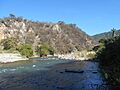
The ruins of Chutixtiox occupy a steep hilltop in a curve of the Río Negro

See also
 In Spanish: Xutixtiox para niños
