
Cifuentes, Cuba facts for kids
Quick facts for kids
Cifuentes
|
|
|---|---|
| Cifuentes Bajare | |

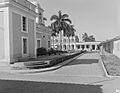
Calle Maceo of Cifuentes in 1947
|
|
.png)
Cifuentes municipality (red) within
Villa Clara Province (yellow) and Cuba |
|
| Country | Cuba |
| Province | Villa Clara |
| Founded | 1819 |
| Established | 1919 (Municipality) |
| Area | |
| • Total | 512 km2 (198 sq mi) |
| Elevation | 65 m (213 ft) |
| Population
(2022)
|
|
| • Total | 26,135 |
| • Density | 51.04/km2 (132.21/sq mi) |
| Time zone | UTC-5 (EST) |
| Area code(s) | +53-422 |
Cifuentes (pronounced see-FWEHN-tess) is a town and a special area called a municipality in Villa Clara Province, Cuba. It was founded in 1819. Later, in 1919, it officially became a municipality.
Contents
About Cifuentes
Cifuentes is a part of Cuba known for its history and people. It is located in the central part of the country. The town has seen many changes over the years.
Population and Size
In 2022, about 26,135 people lived in Cifuentes. This number was lower than in 1976, when there were 41,789 residents. The municipality covers an area of about 512 square kilometers (198 square miles). This means there are about 51 people living in each square kilometer.
A Look at History
Before 1976, Cifuentes was divided into smaller areas called barrios. These included places like Alacrán, Amaro, and Sitio Grande. These divisions helped organize the municipality.
Getting Around Cifuentes
Cifuentes is connected by a railway line. This train line starts in Santa Clara. It passes through several towns, including Vega Alta and Encrucijada. Finally, it loops back to Santa Clara. This railway helps people and goods move around the region.
Images for kids
-
Calle Maceo of Cifuentes in 1947
See also
 In Spanish: Cifuentes (Cuba) para niños
