
Ciudad Serdán facts for kids
Quick facts for kids
Ciudad Serdán
San Andrés Chalchicomula
|
|
|---|---|
|
locality
|
|
 |
|

Ciudad Serdán
Location in Puebla (state)

Ciudad Serdán
Location in Mexico
|
|
| Country | |
| State | Puebla |
| Municipality | Chalchicomula de Sesma Municipality |
| Founded | 1560 |
| Elevation | 2,565 m (8,415 ft) |
| Population
(2010)Municipality
|
|
| • Total | 23,824 |
| Time zone | UTC-6 (Central (US Central)) |
| • Summer (DST) | UTC-5 (Central) |
| Postal code (of seat) |
75520
|
| Area code(s) | 245 |
Ciudad Serdán is a town in the Mexican state of Puebla. It used to be called San Andrés Chalchicomula. This town is the main part, or "municipal seat," of the Chalchicomula de Sesma Municipality.
It is located at 18° 59′ North and 97° 27′ West. This means it's in the northern part of the world, west of the Prime Meridian. The town sits quite high up, about 2,520 m (8,270 ft) above sea level.
Contents
About Ciudad Serdán
Ciudad Serdán is an important place in the state of Puebla, Mexico. It serves as the center for the local government of the Chalchicomula de Sesma Municipality. The town has a rich history, dating back to its founding in 1560.
Where is Ciudad Serdán?
This town is located in the country of Mexico, specifically in the state of Puebla. It's part of the Chalchicomula de Sesma Municipality. Knowing its coordinates helps us find it precisely on a map.
How Many People Live Here?
According to information from 2010, the total population of the municipality was 23,824 people. This number helps us understand how big the community is.
Who Leads the Town?
The leader of the municipality is called the Municipal President. As of the information available, the Municipal President is Juan Navarro. This person helps make decisions for the town and its people.
What is the Weather Like?
Ciudad Serdán uses the Central Time Zone, which is the same as US Central Time. This means it's usually 6 hours behind Coordinated Universal Time (UTC). During daylight saving time, it shifts to 5 hours behind UTC.
Images for kids
-
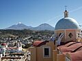
A view from Ciudad Serdán, showing Citlaltépetl and Sierra Negra mountains.
See also
 In Spanish: Ciudad Serdán para niños
