Claysburg, Pennsylvania facts for kids
Quick facts for kids
Claysburg, Pennsylvania
|
|
|---|---|

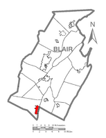
Claysburg (depicted in red) in Blair County
|
|
| Country | United States |
| State | Pennsylvania |
| County | Blair |
| Township | Greenfield |
| Area | |
| • Total | 1.34 sq mi (3.46 km2) |
| • Land | 1.34 sq mi (3.46 km2) |
| • Water | 0.00 sq mi (0.00 km2) |
| Population
(2020)
|
|
| • Total | 1,291 |
| • Density | 965.59/sq mi (372.86/km2) |
| Time zone | UTC-5 (Eastern (EST)) |
| • Summer (DST) | UTC-4 (EDT) |
| ZIP code |
16625
|
| Area code(s) | 814 |
| Local phone exchange | 239 |
Claysburg is a community in Blair County, Pennsylvania, United States. It is a census-designated place (CDP), which means it's a special area defined by the government for gathering population data. Claysburg is located near Interstate 99 and the Allegheny Front, close to a mountain called Blue Knob.
In 2020, about 1,291 people lived in Claysburg.
Population in Claysburg
| Historical population | |||
|---|---|---|---|
| Census | Pop. | %± | |
| 2020 | 1,291 | — | |
| U.S. Decennial Census | |||
The population of Claysburg changes over time. In the year 2000, there were 1,503 people living here. These people lived in 616 different homes.
Most people in Claysburg are White. A small number of people are from other racial backgrounds. About 0.73% of the population in 2000 was of Hispanic or Latino origin.
The community has a mix of age groups. In 2000, about 26.3% of the people were under 18 years old. About 17.3% were 65 years or older. The average age in Claysburg was 36 years old.
History of Claysburg
Claysburg has an interesting history. In 1961, a place called the Claysburg Air Force Station was located here. It was originally known as Blue Knob Park. This station played a role in the area's past.
See also
 In Spanish: Claysburg (Pensilvania) para niños

