
Clevens Loch, Ayrshire facts for kids
Quick facts for kids Clevens Loch |
|
|---|---|

The site of Clevens Loch
|
|

Clevens Loch
Location in Scotland
|
|
| Location | Dundonald, South Ayrshire, Scotland |
| Coordinates | 55°33′14.9″N 4°35′37.2″W / 55.554139°N 4.593667°W |
| Type | Old freshwater loch |
| Primary inflows | Rumbling Burn |
| Primary outflows | Cross Burn |
| Basin countries | Scotland |
| Average depth | Shallow |
| Islands | None |
Clevens Loch was once a large freshwater loch (a Scottish word for lake). It was located in a low-lying area near Clevance Farm and Langholm Farm in Dundonald, Scotland.
Contents
History of Clevens Loch
Clevens Loch was a natural feature. It formed in a "kettle hole," which is a hollow left behind after glaciers melted. The loch was mainly fed by the Rumbling Burn, rainwater, and natural springs.
The name "Clevens" might come from a Scottish word meaning "spear-shaped hill." This could refer to the shape of the valley and hills around the loch. The Rumbling Burn, which once fed the loch, has since been moved. Even today, the area where the loch used to be often floods in winter. Water from the site flows into the Cross Burn.
Langholm Farm's name means "a long piece of low land next to water." This farm is not shown on maps until after the loch was drained. The area itself has been known by different names over time, such as 'Kleffans' in 1654 and 'Clevance' by 1890.
Why the Loch Was Drained
The draining of Clevens Loch likely started in the early 1700s. A local landowner, Alexander Montgomerie, 10th Earl of Eglinton, began improving his large estates for farming. Other landowners soon followed his lead.
More drainage work might have happened in the 1740s. This was part of efforts to create jobs for Irish workers. They needed work during difficult times, like when there wasn't enough food in Ireland. Many drainage projects also took place after World War I. This was when many soldiers returned home and needed employment.
How the Loch Was Used
It seems no watermills were directly connected to Clevens Loch. Old maps from the mid-1800s only show Clevens or Clevance Farm. This farm was located above the old loch's site. A map from 1832 by Thomson shows a mill called Scullochmill. It was near the Crossburn, close to the Clevance Farm road. However, a straight channel of water ran to it directly from the hills above.
Maps of Clevens Loch
Blaeu's map from 1654, based on a survey from around 1604, shows Clevens Loch. It appears as a large body of water with only one outflow.
Ainslie's map from 1821 is the last one to show Clevens Loch. This suggests that the loch was drained in the early 1800s. Its water flowed through the Fullarton estate and into the sea at Newburn. Roy's map from 1747 also shows a loch called Cleavans.
Micro-history of the Area
Corraith House is located on a high spot south of the old loch shore. It was called 'Korreth' in 1654 and Corries in 1747.
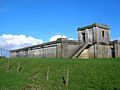
Above the loch, on Wardlaw Hill, are the remains of an old fort. This fort sits on the very top of the hill, about 145 meters above sea level. It has an inner fort or settlement on the highest point. This part has a collapsed stone wall and an entrance that might have been on the north side. A ruined wall from a later time runs along the top of the old fort's wall. Older maps show that spring water once flowed down to the Slough Burn from this site. This is where the Ayrshire County Council water tank was built in 1932.
Adamson, in his book "Rambles Round Kilmarnock" from 1875, wrote about his journey. He mentioned drinking from an open well near the old loch. He described it as "neatly built in, and bears the date 1821."
Images for kids
-
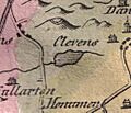
Clevens Loch in 1811.
-
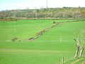
A spring fed burn running down to the loch site.
-
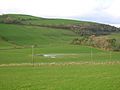
The loch site from Corraith.
-
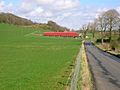
The site of Clevens Loch looking towards Langholm Farm.
-
The old water tank above Langholm Farm.


