
Clifton, Christchurch facts for kids
Quick facts for kids
Clifton
|
|
|---|---|
|
Suburb
|
|
_with_Rapanui_Rock_(right),_Christchurch,_New_Zealand.jpg)
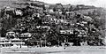
Clifton (above the cliff) and Sumner Bay
|
|

Clifton
Location in New Zealand
|
|
| Country | New Zealand |
| Local authority | Christchurch |
| Electoral ward | Heathcote |
| Area | |
| • Land | 256 ha (633 acre) |
| Population
(June 2023)
|
|
| • Total | 1,820 |
|
|
||
Clifton is a suburb located on a hillside above Sumner in Christchurch, New Zealand. It sits on a part of a former volcano that extends from Tauhinukorokio / Mount Pleasant.
Most of Clifton was first bought by Dr Alfred Barker. He got a special grant for about 50 acres of land. Dr. Barker later sold his land in 1872. The lower part of Clifton was divided into 93 sections and sold in 1903. More land further up the hill was divided and sold in 1908.
A smaller area, once called Lower Clifton, was bought by Samuel Hurst Seager in 1901. He designed and divided this land into 12 plots. This area was sold in 1914 and has been known as The Spur ever since. It's now a main residential area on the hill above Sumner.
Contents
Clifton's Coastal Cliff
Clifton sits on a ridge that goes down from Tauhinukorokio / Mount Pleasant. This ridge ends in a tall cliff right by the sea, at the western end of Sumner beach. The cliff hangs over the road that connects Sumner and Moncks Bay.
Peacocks Gallop: A Name with a Story
The area by the beach is called Peacocks Gallop. This name comes from John Thomas Peacock. He used to ride his horse very fast, or "gallop," along this part of the road. He did this because he was afraid of rocks falling from the cliff!
Earthquake Damage and Art
In 2011 and again in 2016, strong earthquakes caused parts of the cliff to break off. This made the cliff edge move back a lot. Some houses on top of the cliff were damaged or left very close to the edge.
To protect the main road below from more falling rocks, large shipping containers were stacked up. These containers later became a cool outdoor art gallery, with different artworks painted on them.
Who Lives in Clifton?
The Clifton Hill area, which also includes Moncks Bay, covers about 2.56 square kilometers. As of 2023, it has an estimated population of about 1,700 people. This means there are around 660 people living in each square kilometer.
Population Changes Over Time
The number of people living in Clifton Hill has changed over the years:
- In 2006, there were 1,851 people.
- In 2013, the population went down to 1,479.
- In 2018, it increased to 1,647 people.
A Snapshot of the Community (2018)
In 2018, the Clifton Hill area had 1,647 residents living in 624 homes. There were slightly more females (837) than males (807).
The average age of people in Clifton Hill was 47.3 years. This is a bit older than the national average of 37.4 years.
- About 17% of residents were under 15 years old.
- About 13.5% were aged 15 to 29.
- Nearly half (49%) were aged 30 to 64.
- About 20% were 65 years or older.
Most people in Clifton Hill (96.2%) are of European/Pākehā background. Smaller groups include Māori (4%), Asian (2.9%), and Pasifika (0.4%). Some people identify with more than one ethnic group.
About 28% of the people living in Clifton Hill were born outside of New Zealand. This is similar to the national average.
When asked about religion, most people (57.7%) said they had no religion. About 34% identified as Christian. A small number followed other religions like Hindu or Buddhist.
Education and Jobs
Many adults in Clifton Hill have a good education. About 45.5% of people aged 15 or older had a bachelor's degree or higher. Only a small number (8.1%) had no formal qualifications.
The average income in Clifton Hill was $47,900. This was higher than the national average of $31,800. Many people (33.7%) earned over $70,000 a year.
In terms of jobs, about 50% of adults worked full-time. Another 19.7% worked part-time, and 2.6% were unemployed.
Images for kids
-
Clifton Spur in 1920
-
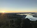
Avon Heathcote Estuary from Clifton Hill


