
Court (District Electoral Area) facts for kids
Quick facts for kids Court |
|
|---|---|
| Belfast City Council DEA Constituency | |

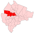
Court DEA marked on a map of Belfast City Council and its wards
|
|
| Current constituency | |
| Created | 1985 |
| Seats | 6 (1985–1993) 5 (1993–2014) 6 (2014–) |
| Councillors | |

Court is an important area in Belfast, Northern Ireland. It is one of ten special areas called District Electoral Areas (DEAs). These areas help organize local elections. Court is located in the north and west parts of Belfast.
This area chooses six people to be members of the Belfast City Council. These members are called councillors. The Court DEA includes several smaller areas known as wards. These wards are Ballygomartin, Clonard, Falls, Forth River, Shankill, and Woodvale. For bigger elections, like those for the Northern Ireland Assembly and the UK Parliament, Court is part of the Belfast North and Belfast West areas.
Contents
Understanding Court: A Local Area in Belfast
How Court DEA Was Created
The Court DEA was first set up for local elections in 1985. It started with six wards. Some of these wards came from older areas called Area E and Area G.
Over time, the wards within Court changed. From 1993 to 2011, it had five wards. These were Crumlin, Glencairn, Highfield, Shankill, and Woodvale. A ward called Saint Anne's was removed.
More changes happened for the 2014 local elections. Crumlin ward was removed. Forth River ward replaced Glencairn. Ballygomartin ward replaced Highfield. Also, Falls and Clonard wards joined Court. They used to be part of another area called Lower Falls.
People and Communities in Court DEA
Understanding the people who live in Court is important. The 2011 census collected information about the population. This helps us learn about the communities in the area.
The total population of Court in 2011 was 21,886 people. The area covers about 9.12 square kilometers. This means there are about 2,400 people living in each square kilometer.
Here is a quick look at the wards and their populations in 2011:
- Crumlin: 4,582 people
- Glencairn: 3,749 people
- Highfield: 5,651 people
- Shankill: 3,816 people
- Woodvale: 4,088 people
These numbers show how many people lived in each part of Court at that time.
Meet Your Councillors: Representing Court
Councillors are elected to represent the people of Court. They work on local issues and make decisions for the community. The number of councillors for Court has changed over the years. It had six seats from 1985 to 1993. Then it had five seats from 1993 to 2014. Since 2014, it has gone back to six seats.
Current Councillors (2023 Election)
After the 2023 election, the councillors representing Court are:
- Christina Black (Sinn Féin)
- Claire Canavan (Sinn Féin)
- Frank McCoubrey (DUP)
- Ron McDowell (TUV)
- Ian McLaughlin (DUP)
- Nicola Verner (DUP)
These councillors work to make Court a better place for everyone.
How Councillors Are Elected
Councillors in Northern Ireland are elected using a system called Single Transferable Vote (STV). This system allows voters to rank candidates in order of preference. It helps to make sure that different groups in the community are represented.
When you see election results, you might see terms like "quota" and "counts." The quota is the number of votes a candidate needs to be elected. Counts show how votes are moved between candidates until all seats are filled.
Images for kids
-
Wards of Court DEA in Belfast from 1993 to 2014 (see census table)

