Crabtree, Pennsylvania facts for kids
Quick facts for kids
Crabtree
|
|
|---|---|

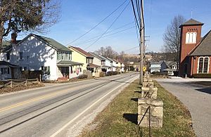
The main street, US Route 119, looking northeast from Cemetery Drive. Houses built for miners visible at left.
|
|
| Country | United States |
| State | Pennsylvania |
| County | Westmoreland |
| Area | |
| • Total | 0.09 sq mi (0.24 km2) |
| • Land | 0.09 sq mi (0.24 km2) |
| • Water | 0.00 sq mi (0.00 km2) |
| Population
(2020)
|
|
| • Total | 201 |
| • Density | 2,161.29/sq mi (832.37/km2) |
| Time zone | UTC-5 (Eastern (EST)) |
| • Summer (DST) | UTC-4 (EDT) |
| ZIP codes |
15624
|
| FIPS code | 42-16816 |
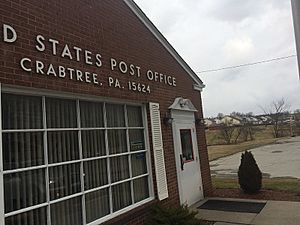
Crabtree is a small community in Westmoreland County, Pennsylvania, United States. It is a "census-designated place" (CDP), which means it's an area defined for counting people by the government. Crabtree was once a busy coal town, where many people worked in the coal mines. In 2020, about 201 people lived there. It has its own post office with the postal code 15624.
Contents
History of Crabtree
From Goff to Crabtree
The area we know as Crabtree today was first called Goff. This name was used until the early 1900s.
Coal Mining Begins
In the 1880s, a company called Thomas Donohoe's Alexandria Coal Company started mining coal nearby. They also built special houses in the town for their workers. These were called "company houses."
In 1901, another company, Jamison Coal & Coke Company, bought the mine. They renamed it the No. 4 mine. This mine had two entrances, one in Salem Township and another in Unity Township. A train line, the Alexandria Branch of the Pennsylvania Railroad, helped transport the coal from the No. 4 mine.
Town Growth and Name Change
The Jamison Coal & Coke Company made the town of Goff bigger. They built more houses in both Unity and Salem townships. As the town grew, its name was changed to Crabtree in 1908. The original small village of Crabtree, which was about two miles away, then became known as Old Crabtree.
The Jamison No. 4 mine was very important to the town. At one point, it employed between 350 and 400 people. Both the No. 4 and No. 5 mines continued to operate through the 1930s. Later, a different type of mining, called strip mining, began along Crabtree Creek.
Geography of Crabtree
Crabtree is located in Pennsylvania. Its exact coordinates are 40°21′48″N 79°28′11″W / 40.36333°N 79.46972°W.
According to the United States Census Bureau, Crabtree covers a total area of about 0.1 square miles (0.24 square kilometers). All of this area is land, meaning there are no large bodies of water like lakes or rivers within the CDP.
Population Information
| Historical population | |||
|---|---|---|---|
| Census | Pop. | %± | |
| 2020 | 201 | — | |
| U.S. Decennial Census | |||
In the year 2000, there were 320 people living in Crabtree. There were 147 households, which means 147 different homes where people lived. About 98 of these were families.
The average number of people living in each home was about 2.16. For families, the average was about 2.61 people.
See also
 In Spanish: Crabtree (Pensilvania) para niños
 | Shirley Ann Jackson |
 | Garett Morgan |
 | J. Ernest Wilkins Jr. |
 | Elijah McCoy |


