Cristóbal Island facts for kids
|
Native name:
Isla San Cristóbal
|
|
|---|---|

Bocas del Toro Archipelago
|
|
| Geography | |
| Coordinates | 9°21′N 82°14′W / 9.350°N 82.233°W |
| Archipelago | Bocas del Toro Archipelago |
| Area | 37 km2 (14 sq mi) |
| Highest elevation | 118 m (387 ft) |
| Highest point | Cerro Botabite II |
| Administration | |
| Province | Bocas del Toro |
| District | Bocas del Toro |
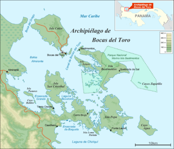
Cristóbal Island (in Spanish: Isla San Cristóbal) is a beautiful island in Panama. Its name means "Saint Christopher's Island." It is about 37 square kilometers in size. This island is part of the Bocas del Toro Archipelago.
Cristóbal Island is located south of Isla Colón. Much of the island's original forest has been cut down over time.
Who Lives on Cristóbal Island?
The island is home to the Ngäbe people. They are an indigenous group, meaning they are the original inhabitants of this land. You might also hear them called the Guaymí people.
Besides the Ngäbe people, a small number of expatriates live on the island. Expatriates are people who live in a country that is not their home country.
Dolphin Bay: A Special Place
On the east side of Cristóbal Island, you will find a special place called Laguna Bocatorito. This bay is also widely known as Dolphin Bay.
It gets its name because many dolphins live and play in its waters. It is a popular spot for visitors to see these amazing creatures.
See also
 In Spanish: Isla de San Cristóbal (Panamá) para niños
- List of islands of Panama

