
Bocas del Toro Province facts for kids
Quick facts for kids
Bocas del Toro Province
Provincia de Bocas del Toro
|
||
|---|---|---|

Bocas del Toro provincial headquarters
|
||
|
||

Bocas del Toro, in red, in Panama
|
||
| Country | ||
| Founded | 1903 | |
| Capital | Bocas del Toro | |
| Districts | Almirante, Bocas del Toro, Changuinola, Chiriquí Grande | |
| Area | ||
| • Total | 4,657.2 km2 (1,798.2 sq mi) | |
| Population
(2010)
|
||
| • Total | 125,461 | |
| • Density | 26.9391/km2 (69.7721/sq mi) | |
| Demonym(s) | Bocatoreño | |
| Time zone | UTC+1 (Eastern Time) | |
| • Summer (DST) | UTC-5 (CEST) | |
| ISO 3166 code | PA-1 | |

Bocas del Toro (which means "Mouths of the Bull") is a province in the country of Panama. It is located in the northwestern part of Panama, right next to Costa Rica. The main city and capital of the province is Bocas del Toro, found on Colón Island.
Contents
History of Bocas del Toro
Early Explorations and Naming
In 1502, the famous explorer Christopher Columbus visited this area. He was on his fourth trip to the Americas, looking for a way to the Pacific Ocean. He named the island we now call Colón Island "Isla del Drago," which means "Dragon's Island."
Becoming a Province
During the time when countries were colonies, Bocas del Toro was part of the Veraguas province. Later, when Panama was part of Colombia, the government created the district of Bocas del Toro in 1834. Over the years, it moved between being part of Chiriquí and Colón.
Finally, on November 16, 1903, Bocas del Toro officially became its own separate province. In 1941, it was divided into two main areas, called districts. More changes happened in 1970 when new districts were made. The borders of these districts changed again in 1997 when the Ngäbe-Buglé comarca (a special indigenous territory) was created.
Where is Bocas del Toro?
The Bocas del Toro province is located on the Caribbean coast of Panama. To the north, it touches the Caribbean Sea. To the west, it borders the Limón Province in Costa Rica. The Chiriquí Province is to its south, and the Ngäbe-Buglé Comarca is to its east. The Sixaola river forms part of the border with Costa Rica.
 |
Caribbean Sea | |
||
| Limón province (Costa Rica) | Ngäbe-Buglé Comarca | |||
| Chiriquí province |
Geography of the Province
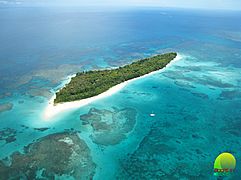
Bocas del Toro province covers an area of about 4,657 square kilometers (1,798 square miles). A big part of the province includes the Bocas del Toro Archipelago. An archipelago is a group of many islands. These islands are in the Caribbean Sea.
Main Islands
The most important islands in this archipelago are:
- Colón Island: This island is about 61 square kilometers (24 square miles). It is home to the city of Bocas del Toro, which is the capital of the province.
- Popa Island: This island is about 53 square kilometers (20 square miles).
- Bastimentos Island: It is about 52 square kilometers (20 square miles).
- San Cristóbal Island: This island is about 37 square kilometers (14 square miles).
- Cayo Agua Island: It is about 16 square kilometers (6 square miles).
- Solarte Island: This island is about 8 square kilometers (3 square miles).
- Carenero Island: It is about 4 square kilometers (2 square miles).
Protected Natural Areas
Bocas del Toro is home to some important national parks that protect nature. These include:
- Isla Bastimentos National Marine Park: This park protects most of Bastimentos Island and some smaller islands nearby. It's a great place to see marine life.
- La Amistad International Park: This huge park stretches across the border between Costa Rica and Panama. Bocas del Toro has a large part of the Panamanian section of this park. It covers about 400,000 hectares (1,544 square miles) in Panama.
Climate
| Climate data for Bocas del Toro (1971-2000) | |||||||||||||
|---|---|---|---|---|---|---|---|---|---|---|---|---|---|
| Month | Jan | Feb | Mar | Apr | May | Jun | Jul | Aug | Sep | Oct | Nov | Dec | Year |
| Mean daily maximum °C (°F) | 30.8 (87.4) |
30.7 (87.3) |
31.0 (87.8) |
31.4 (88.5) |
31.9 (89.4) |
32.0 (89.6) |
31.5 (88.7) |
31.8 (89.2) |
31.9 (89.4) |
31.7 (89.1) |
31.6 (88.9) |
31.0 (87.8) |
31.4 (88.6) |
| Mean daily minimum °C (°F) | 20.4 (68.7) |
20.2 (68.4) |
20.5 (68.9) |
21.4 (70.5) |
22.2 (72.0) |
22.2 (72.0) |
21.7 (71.1) |
21.8 (71.2) |
22.0 (71.6) |
22.0 (71.6) |
21.8 (71.2) |
20.6 (69.1) |
21.4 (70.5) |
| Average precipitation mm (inches) | 123.9 (4.88) |
266.1 (10.48) |
83.8 (3.30) |
369.1 (14.53) |
178.3 (7.02) |
259 (10.2) |
420.1 (16.54) |
440.7 (17.35) |
311.2 (12.25) |
150.5 (5.93) |
291.7 (11.48) |
563.6 (22.19) |
3,458 (136.15) |
| Average precipitation days | 16.6 | 14.6 | 14.8 | 15.2 | 16.7 | 17.9 | 20.9 | 18.4 | 15.8 | 16.4 | 17 | 20.0 | 204.3 |
| Source: World Meteorological Organization | |||||||||||||
People of Bocas del Toro
The people who live in Bocas del Toro province are called Bocatoreños. If they are women, they are called Bocatoreñas.
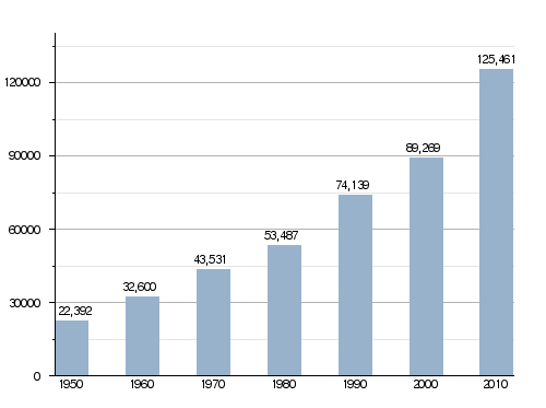
In 2010, the province had a population of 125,461 people. This means there were about 27 people living in every square kilometer.
How the Population of Bocas del Toro Province Has Grown
How Bocas del Toro is Divided
The Bocas del Toro province is split into four main areas called districts. These districts are then divided into smaller parts called corregimientos. A new district called Almirante was created in 2015 from part of the Changuinola district.
| Districts | Corregimientos | Capital |
|---|---|---|
| Almirante | Puerto Almirante, Barriada Guaymí, Barrio Francés, Nance de Riscó, Valle de Aguas Arriba, Valle de Riscó | Puerto Almirante |
| Bocas del Toro | Bocas del Toro, Isla Bastimentos, Cauchero, Punta Laurel, Tierra Oscura | Bocas del Toro |
| Changuinola | Changuinola, Barriada 4 de Abril, Finca 30, Finca 6, Finca 60, Guabito, El Teribe, El Empalme, El Silencio, Las Tablas, Las Delicias, Cochigro, La Gloria | Changuinola |
| Chiriquí Grande | Chiriquí Grande, Bajo Cedro, Miramar, Punta Peña, Punta Robalo, Rambala | Chiriquí Grande |
Economy of the Province
The main way people earn money on the mainland of Bocas del Toro is through farming. The most important commercial crop grown here is plantains. On the islands, the main activities are fishing and tourism. Many visitors come to enjoy the beautiful beaches and nature.
Gallery
-
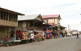
The town of Bocas del Toro.
-
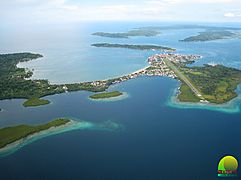
City of Isla Colón.
-
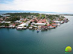
City of Isla Colón.
-
Zapatilla Island, Bocas del Toro.
.jpg)


See also
 In Spanish: Provincia de Bocas del Toro para niños
