
Crosskirk Broch facts for kids
Quick facts for kids Crosskirk Broch |
|
|---|---|
| Crosskirk, Caithness, Scotland | |

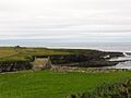
Crosskirk Broch memorial cairn, overlooking the site of the broch.
|
|

Location in Caithness
|
|
| Coordinates | 58°36′30″N 3°40′48″W / 58.608197°N 3.679948°W |
| Site information | |
| Condition | Destroyed by the sea |
| Site history | |
| Built | Iron age |
| Materials | Stone |
Crosskirk Broch was an ancient fort located near the village of Crosskirk in Caithness, Scotland. It was a special kind of building called a broch. Brochs are large, round stone towers built for defense. This one was unique because it was built inside an even older fort.
Sadly, the site became unsafe due to the sea eroding the land. After archaeologists carefully studied it, the broch was taken down in 1972 to prevent it from falling into the sea.
Contents
Uncovering the Past: History of Crosskirk Broch
The area where Crosskirk Broch stood was first used by people at the end of the Bronze Age. This was a time when people used bronze tools. Later, in the early Iron Age, people started using iron.
Archaeologists found special pottery from the early Iron Age. This pottery had a sharp edge, like a carine, and was probably made locally. It looked similar to pottery found in other parts of England from the same time. Scientists used radiocarbon dating to figure out that this pottery was made around 600 to 500 BC.
New People, New Ideas
During the middle Iron Age, things changed at Crosskirk. The buildings were rebuilt, and new types of pottery and tools appeared. This suggests that new people might have moved into the area. These new people likely brought fresh ideas and ways of doing things.
People continued to live here even when the Roman Empire was active in southern Scotland (around 80-180 AD). Some Roman pottery and glass were found, showing they might have traded with the Romans.
Around the time the site was left empty, a body was buried in a sitting position inside a round building. No special items were buried with the person.
Later Discoveries
Much later, around 600 AD, traces of two long stone-lined graves, called cist burials, were found in the broch's ruins.
There was also a stone with runic writing from the time of the Norsemen (Vikings). These Vikings raided and settled in Scotland during the 9th, 10th, and 11th centuries. This stone is now lost.
A ruined church, St Mary's Chapel (Crosskirk), was built nearby around the 13th century. It stands about 30 yards (27 meters) south of where the broch was. Some of the land near the broch was flattened when the chapel was built. In more recent times, stones from the broch mound were taken away, perhaps to build stone walls for fields.
Building a Stronghold: Structure of Crosskirk Broch
The Crosskirk Broch was built inside an older defensive structure. This older structure was a "promontory fort." A promontory is a piece of land that sticks out into the sea. The fort had an outer wall, or rampart, made of rock with an earth core. This wall was about 15 feet (4.5 meters) thick.
There was a gateway that got wider towards the outside, allowing people to enter. The rampart also had a small room, like a cell, built into it.
The Broch's Design
Based on radiocarbon dating, the broch itself was built around 200 BC. It was used until about the 2nd century AD. When it was new, the broch would have looked very strong, rising above the older defense wall.
Inside the broch's thick wall, there was a guard cell and another room, called an intramural chamber. There was also a stairway entrance at ground level. However, the broch's wall was not built very well. It had a core of earth, loose stones, and boulders. This might mean it was an early, experimental type of broch. It probably wasn't strong enough to be as tall as later brochs.
A Village Around the Tower
Around the main tower, there were other buildings. These buildings formed a small village. This kind of arrangement, with houses outside the broch, is mostly found in northern Scotland. These houses were used at the same time the broch was finished.
Over the next two centuries, the broch was repaired many times. But its weak design meant it was always in poor condition. Meanwhile, the houses in the village outside the broch were improved. The site was used one last time in the 2nd century AD. The broch was fixed up before everyone finally left it for good. During this last period, it seems people weren't worried about attacks.
Daily Life: Economy of Crosskirk
The people living at Crosskirk had a good and varied diet. They mostly grew barley, a type of grain. They also grew other plants like fat hen, sorrel, and chickweed. These plants were likely grown on purpose because they had medicinal or nutritional value.
The community raised cattle and some sheep. They were able to keep their animals alive through the cold winters. They also ate shellfish, like limpets, winkles, and whelks, which they collected from the sea. Seabirds were also part of their diet.
Evidence from nearby sites shows that people also fished for deep-sea fish like plaice and cod. They also ate venison, which is deer meat. All this shows that the people at Crosskirk had plenty to eat and could mostly provide for themselves.
Saving History: Excavation and Destruction
In 1871, someone described the broch. They said it was about 30 to 32 feet (9 to 9.7 meters) across inside, with walls 14 to 15 feet (4.2 to 4.5 meters) thick. Part of the wall was exposed near the cliff edge.
By 1964, the broch was mostly covered in grass. The wall was only about 3.6 feet (1.1 meters) high on the inside. The cliff edge was eroding, which meant the sea was slowly eating away at the land. This made the site very unsafe.
Because of the danger, archaeologists Fairhurst and Taylor carefully dug up and studied the ruins between 1966 and 1972. After their work was done, the remains of the broch were pushed over the cliff by a bulldozer. This was done to prevent the ruins from falling into the sea naturally. The site was then covered with grass, and a memorial stone was put up to remember the broch.
Images for kids
-
St Mary's Chapel, Crosskirk, from a distance. The chapel is outlined against the sea near the left of the picture. It stands about 30 yards (27 meters) to the south of the broch.
_position.jpeg)
