Curridabat facts for kids
Quick facts for kids
Curridabat
|
|
|---|---|
|
District
|
|

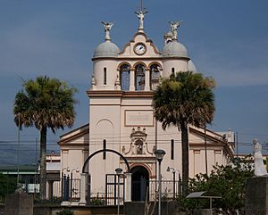
Catholic church in downtown Curridabat
|
|
| Country | |
| Province | San José |
| Canton | Curridabat |
| Area | |
| • Total | 6.16 km2 (2.38 sq mi) |
| Elevation | 1,208 m (3,963 ft) |
| Population
(2011)
|
|
| • Total | 28,817 |
| • Density | 4,678/km2 (12,116/sq mi) |
| Time zone | UTC−06:00 |
| Postal code |
11801
|
Curridabat is a district located in the Curridabat canton. It is part of the San José province in Costa Rica.
Contents
About Curridabat
Curridabat covers an area of about 6.16 square kilometers. It sits at an elevation of 1,208 meters above sea level.
This district is found on the eastern edge of San José, which is the capital city. It is north of Desamparados Canton and south of Montes de Oca Canton.
People of Curridabat
| Historical population | |||
|---|---|---|---|
| Census | Pop. | %± | |
| 1864 | 1,026 | — | |
| 1883 | 1,227 | 19.6% | |
| 1892 | 1,930 | 57.3% | |
| 1927 | 2,551 | 32.2% | |
| 1950 | 2,485 | −2.6% | |
| 1963 | 5,764 | 132.0% | |
| 1973 | 9,581 | 66.2% | |
| 1984 | 19,821 | 106.9% | |
| 2000 | 30,316 | 52.9% | |
| 2011 | 28,817 | −4.9% | |
|
Instituto Nacional de Estadística y Censos |
|||
According to the 2011 census, Curridabat had a population of 28,817 people.
Getting Around
Roads in Curridabat
Many important roads pass through the Curridabat district. These roads help people travel easily.
Here are some of the main road routes:
 National Route 2
 National Route 210
 National Route 211
 National Route 215
 National Route 221
 National Route 251
 National Route 252
Train Travel
The Interurbano Line also runs through this district. This train service is operated by Incofer.
See also
 In Spanish: Curridabat para niños
 | Lonnie Johnson |
 | Granville Woods |
 | Lewis Howard Latimer |
 | James West |


