Dahlgren, Virginia facts for kids
Quick facts for kids
Dahlgren, Virginia
|
|
|---|---|

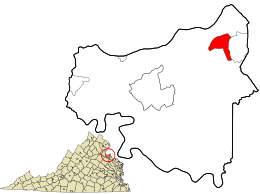
Location in King George County and the state of Virginia
|
|
| Country | United States |
| State | Virginia |
| County | King George |
| Area | |
| • Total | 2.80 sq mi (7.24 km2) |
| • Land | 2.69 sq mi (6.98 km2) |
| • Water | 0.10 sq mi (0.25 km2) |
| Elevation | 20 ft (6 m) |
| Population
(2010)
|
|
| • Total | 2,653 |
| • Density | 984/sq mi (380.0/km2) |
| Time zone | UTC−5 (Eastern (EST)) |
| • Summer (DST) | UTC−4 (EDT) |
| ZIP codes |
22448, 22485
|
| Area code(s) | 540 |
| FIPS code | 51-21008 |
| GNIS feature ID | 1465571 |
Dahlgren is a small community in King George County, Virginia, United States. It's a place where people live and work, and it's counted as a "census-designated place" (CDP). This means it's a specific area defined for gathering population information. In 2020, about 2,946 people lived here.
Contents
Since 1918, Dahlgren has been home to an important U.S. naval base. This base is named after Rear Admiral John A. Dahlgren, a famous naval officer.
The base has had several names over the years. It started as the "U.S. Naval Proving Ground" in 1918. This was a place where new weapons and equipment were tested.
After 1950, it became the "U.S. Naval Weapons Laboratory." Then, in 1974, it was called the "Naval Surface Weapons Center." In 1987, it changed to the "Naval Surface Warfare Center." Around 1990, it became the "U.S. Naval Surface Warfare Center Dahlgren Division (NSWCDD)."
In 2006, the base was renamed "Naval Support Activity-South Potomac (NSA-SP)." The NSWCDD then became a main part of this larger base.
Important Work at the Base
The U.S. Naval Space Surveillance Systems command used to be at this base. They watched things in space for the Navy. This job was later given to the Air Force in 2004.
Today, the AEGIS Training and Readiness Center is also located at NSA-SP. This center trains people to use a very advanced defense system for ships. The naval base itself is just east of the Dahlgren community.
Geography of Dahlgren
Dahlgren is located in the northeastern part of King George County. It is about 1 mile south and 2 miles west of the Potomac River. This river is a major waterway in the region.
Dahlgren's Borders and Roads
The Naval Surface Warfare Center Dahlgren Division borders Dahlgren to the east. To the north, Dahlgren reaches state route 635. The community of Owens is to the west. To the south, Dahlgren extends to the Upper Machodoc Creek, which is connected to the Potomac River.
U.S. Route 301, also known as the James Madison Parkway, goes right through Dahlgren. This road helps people travel. It goes northeast across the Potomac River for about 18 miles to La Plata, Maryland. It also goes southwest for about 15 miles to Port Royal, Virginia.
Land and Water Area
Dahlgren covers a total area of about 7.2 square kilometers (2.8 square miles). Most of this area, about 7.0 square kilometers (2.7 square miles), is land. The remaining 0.25 square kilometers (0.1 square miles) is water.
Population in Dahlgren
In 2000, there were 997 people living in Dahlgren. By 2010, the population had more than doubled to 2,653 people. This shows that more people are choosing to live in Dahlgren. The population continued to grow, reaching 2,946 people by the 2020 census.
Fun Things to Do in Dahlgren
Dahlgren offers some interesting places to visit and activities to enjoy.
Dahlgren Heritage Museum
The Dahlgren Heritage Museum is a great place to learn about the area's history. It focuses on the U.S. Navy's presence in Dahlgren and the local community's traditions.
- Civil War History: You can see a small model of a Civil War-era Dahlgren gun. This was a type of cannon designed by Rear Admiral John A. Dahlgren.
- Flight History: The museum also has the propeller from the first radio-controlled, unmanned flight. This is a cool piece of aviation history!
- World War II Technology: Another interesting item is a Norden bombsight, a device used in airplanes during World War II.
Outdoor Activities and Unique Sights
Machodoc Creek has a full-service marina. This is a place where boats can be docked and serviced. It's great for people who enjoy being on the water.
For something a bit different, check out the Raptor Challenge. This is a fun roadside attraction where visitors try to find statues of Velociraptors along Route 301. It's like a scavenger hunt!
Important Roads and Businesses
Dahlgren is connected by a major road and has a growing business area.
Governor Harry W. Nice Memorial Bridge
The Governor Harry W. Nice Memorial Bridge is about 1.7 miles (2.7 kilometers) long. It's part of U.S. Route 301 and helps traffic cross the wide Potomac River at Dahlgren. This bridge offers another way to travel instead of using Interstate 95.
Local Businesses
Along Route 301 in Dahlgren, you'll find a growing number of small businesses. These businesses serve the local community and visitors.
See also
 In Spanish: Dahlgren (Virginia) para niños

