Deer Creek, Taylor County, Wisconsin facts for kids
Quick facts for kids
Deer Creek, Wisconsin
|
|
|---|---|

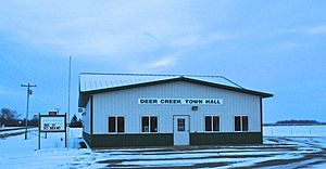
Deer Creek Town Hall in November 2013.
|
|

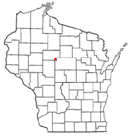
Location of Deer Creek, Taylor County, Wisconsin
|
|
| Country | |
| State | |
| County | Taylor |
| Area | |
| • Total | 34.2 sq mi (88.7 km2) |
| • Land | 34.2 sq mi (88.6 km2) |
| • Water | 0.0 sq mi (0.0 km2) |
| Elevation | 1,457 ft (444 m) |
| Population
(2000)
|
|
| • Total | 733 |
| • Density | 21.4/sq mi (8.3/km2) |
| Time zone | UTC-6 (Central (CST)) |
| • Summer (DST) | UTC-5 (CDT) |
| Area code(s) | 715 & 534 |
| FIPS code | 55-19225 |
| GNIS feature ID | 1583059 |
| PLSS township | T30N R2E |
Deer Creek is a town in Taylor County, Wisconsin, United States. Part of the village of Stetsonville is also located in Deer Creek. In 2000, about 733 people lived here.
Contents
Exploring Deer Creek's Landscape
Deer Creek covers an area of about 34.2 square miles (88.7 square kilometers). Most of this area is land, with very little water.
The land in Deer Creek is mostly flat. This flat surface was created by ancient glaciers. These huge ice sheets moved across the land long ago. They left behind a type of soil called "till." The soil in Deer Creek is mainly Merrill till and Edgar till.
A Look Back at Deer Creek's Past
Early Surveys and Land Descriptions
The area that is now Deer Creek was first mapped in 1851. This was done by teams working for the U.S. government. In 1854, other surveyors marked all the corners of the land sections. They walked through forests and swamps to do this.
After their work, a surveyor wrote about the land. He said there were many swamps not good for farming. The soil was poor, with rocks and gravel. The trees were mostly hemlock and birch, which were not very valuable. He also noted that there was no good pine timber. However, the area had many small streams.
The Arrival of the Railroad
Around 1873, the Wisconsin Central Railroad Company built a train line nearby. This line went through the forest, heading towards Medford and Ashland. The railroad helped open up the land for new settlers. To pay for building the tracks, the railroad was given half of the land for eighteen miles on each side of the track.
Settlement and Growth
An 1880 map shows early roads in the area. These roads followed where modern Highway 13 and Apple Avenue are today. A farm belonging to A.J. Cliveland was marked on the map.
By 1900, more settlers had moved to Deer Creek. More roads were built, and farms became common. The town hall was located a mile east of Stetsonville. There were also two rural schools. A sawmill was in section 26, and a "Poor Farm" was in the northwest corner. The Wisconsin Central Railroad still owned large parts of the land.
The 1911 map showed even more settlers. More roads connected different parts of the town. New schools had also appeared. However, some large areas, especially in the east and south, were still empty.
People of Deer Creek
In 2000, Deer Creek had 733 residents. There were 241 households and 201 families living in the town. The population density was about 21.4 people per square mile. Most of the people living in Deer Creek were White.
Many households (44.4%) had children under 18 living with them. Most families (73.9%) were married couples. The average household had about 3 people, and the average family had about 3.3 people.
The population included people of all ages. About 31.7% were under 18 years old. The median age was 34 years. This means half the people were younger than 34 and half were older.
The average income for a household in Deer Creek was $49,688. For families, the average income was $51,607. About 7.7% of the population lived below the poverty line. This included 9.2% of those under 18.
See also
 In Spanish: Deer Creek (condado de Taylor, Wisconsin) para niños
 | Madam C. J. Walker |
 | Janet Emerson Bashen |
 | Annie Turnbo Malone |
 | Maggie L. Walker |

