Dentsville, South Carolina facts for kids
Quick facts for kids
Dentsville, South Carolina
|
|
|---|---|

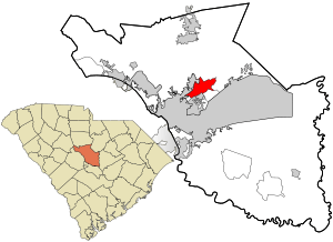
Location in Richland County and the state of South Carolina.
|
|
| Country | United States |
| State | South Carolina |
| County | Richland |
| Area | |
| • Total | 6.82 sq mi (17.67 km2) |
| • Land | 6.69 sq mi (17.33 km2) |
| • Water | 0.13 sq mi (0.35 km2) |
| Elevation | 230 ft (70 m) |
| Population
(2020)
|
|
| • Total | 14,431 |
| • Density | 2,156.78/sq mi (832.77/km2) |
| Time zone | UTC−5 (Eastern (EST)) |
| • Summer (DST) | UTC−4 (EDT) |
| FIPS code | 45-19285 |
| GNIS feature ID | 1249475 |
Dentsville is a special kind of place in Richland County, South Carolina. It's called a census-designated place (CDP). This means it's an area that the government counts as a town for population numbers, but it doesn't have its own city government like a regular town or city.
In 2010, about 14,062 people lived in Dentsville. It is also part of the larger Columbia, South Carolina area. This bigger area is known as the Metropolitan Statistical Area.
Contents
Where is Dentsville Located?
Dentsville is found at specific coordinates: 34.075403 degrees North and 80.955207 degrees West. These numbers help pinpoint its exact spot on a map.
Land and Water Area
The total area of Dentsville is about 17.9 square kilometers. Most of this area is land, measuring around 17.5 square kilometers. A small part, about 0.3 square kilometers, is water. This means water makes up about 1.93% of Dentsville's total area.
Who Lives in Dentsville?
The population of Dentsville has grown over time. In 2020, the census counted 14,431 people living there.
Households and Families
The 2020 census also showed that there were 6,403 households in Dentsville. A household is a group of people living together in one home. Out of these, 3,599 were families. This means Dentsville is home to many different kinds of families and people.
See also

- In Spanish: Dentsville (Carolina del Sur) para niños

