Desamparados facts for kids
Quick facts for kids
Desamparados
|
|
|---|---|
|
District
|
|

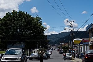
One of the main streets in downtown Desamparados
|
|
| Country | |
| Province | San José |
| Canton | Desamparados |
| Area | |
| • Total | 3.31 km2 (1.28 sq mi) |
| Elevation | 1,161 m (3,809 ft) |
| Population
(2011)
|
|
| • Total | 33,866 |
| • Density | 10,231/km2 (26,500/sq mi) |
| Time zone | UTC−06:00 |
| Postal code |
10301
|
Desamparados is a district in Costa Rica. It is part of the Desamparados canton. This district is located in the San José province.
Contents
Geography of Desamparados
Desamparados covers an area of about 3.31 square kilometers. That's like a small town! The district is located at an elevation of 1,161 meters. This means it is quite high up, which can affect the weather.
Population of Desamparados
The number of people living in Desamparados has changed over time. In 2011, about 33,866 people lived there. This information comes from the 2011 census. A census is a count of all the people in a place.
| Historical population | |||
|---|---|---|---|
| Census | Pop. | %± | |
| 1864 | 965 | — | |
| 1883 | 969 | 0.4% | |
| 1892 | 1,207 | 24.6% | |
| 1927 | 1,502 | 24.4% | |
| 1950 | 4,064 | 170.6% | |
| 1963 | 11,511 | 183.2% | |
| 1973 | 30,659 | 166.3% | |
| 1984 | 43,352 | 41.4% | |
| 2000 | 36,437 | −16.0% | |
| 2011 | 33,866 | −7.1% | |
|
Instituto Nacional de Estadística y Censos |
|||
Getting Around Desamparados
Road Connections
Several important roads pass through Desamparados. These roads help people travel to and from the district. They connect Desamparados to other parts of Costa Rica.
Here are some of the main road routes:
See also
 In Spanish: Desamparados (Costa Rica) para niños
 | Delilah Pierce |
 | Gordon Parks |
 | Augusta Savage |
 | Charles Ethan Porter |


