
Dodman Point facts for kids
Quick facts for kids Dodman Point |
|
|---|---|

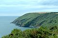
Dodman Point from the south west
|
|

Location in Cornwall
|
|
| Location | Cornwall |
| Coordinates | 50°13′10″N 4°48′07″W / 50.219534°N 4.802055°W |
| Elevation | 373.88 feet (114 m) |
| Operator | National Trust |
| Designation | Scheduled monument |
Dodman Point is a tall piece of land that sticks out into the sea. You can find it near Mevagissey on the south coast of Cornwall, England. It's the highest point of land like this in the area, standing about 374 feet (114 meters) tall!
People sometimes called it the Deadman or Deadman's Point a long time ago. This special place has a long history.
Contents
Dodman Point: A Historic Headland
Dodman Point is more than just a tall cliff. It's a place with ancient secrets and important landmarks.
Ancient History
Long, long ago, during the Iron Age, people built a special fort here. This fort was called a promontory fort. It used the natural shape of the land to protect itself. Imagine a fort built on a high, narrow piece of land with steep cliffs all around! This made it very hard for enemies to attack.
The Granite Cross
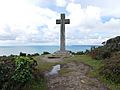
At the very end of Dodman Point, facing the sea, stands a huge granite cross. This cross was put there in 1896. Its main job was to help ships avoid crashing into the dangerous headland. It acted like a warning sign for sailors.
A Sailor's Song
Dodman Point is even mentioned in an old sailor's song! The shanty, called Spanish Ladies, talks about different places sailors would pass. This shows how well-known Dodman Point was to people traveling by sea.
Nearby Attractions
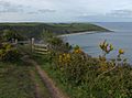
Just to the north-east of Dodman Point, you'll find a lovely, sheltered spot. It's called Gorran Haven. This small area has a quiet anchorage for boats and a sandy beach. It's a great place to visit, especially when the wind is blowing from the west.
Exploring the Cliffs
If you're feeling adventurous, there's a path down to the bottom of the small cliffs below the big stone cross. Some people enjoy climbing here. It's mostly bouldering, which means climbing on large rocks or small cliffs without ropes. Because it's not climbed very often, there aren't any fixed ropes or anchors.
Gallery
-
Viewed from the east
-
Viewed from the west
-
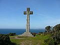
The Cross
-
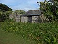
The Watch House

.jpg)
.jpg)
.jpg)
Images for kids
-
Parson Martin's Cross

