Dowker Island facts for kids
|
l'Île Dowker
|
|
|---|---|
| Geography | |
| Location | Saint Lawrence River |
| Coordinates | 45°24′10″N 73°53′40″W / 45.40278°N 73.89444°W |
| Archipelago | Hochelaga Archipelago |
| Area | 1 km2 (0.39 sq mi) |
| Length | 1 km (0.6 mi) |
| Width | 1 km (0.6 mi) |
| Administration | |
|
Canada
|
|
| Province | Quebec |
| City | Notre-Dame-de-l'Île-Perrot |
Dowker Island is a quiet, empty island in Lake Saint Louis. This lake is actually a wider part of the Saint Lawrence River, located south of Montreal. The island is part of the town of Notre-Dame-de-l'Île-Perrot, which wants to keep it natural.
The island is about 1 kilometer (0.6 miles) long and wide. It's mostly flat and low, meaning it can sometimes get flooded. It's also a home for animals like muskrats.
History of Dowker Island
Dowker Island was once known as one of the îles Sainte-Geneviève. These islands included what are now Dowker, Madore, and Daoust islands. In 1672, the island was given to François-Marie Perrot, who was the governor of Montreal. He received it from Jean Talon, along with another island called île Perrot.
Later, in 1897, a person named Leslie Rose Dowker bought the island. He later became the mayor of Sainte-Anne-du-Bout-de-l'Île. Today, that town is known as Sainte-Anne-de-Bellevue.
In the 1940s, a man named Gerard Tardiff owned a large summer house on the island. He was a notary public from Pointe-Claire. A notary public is someone who can legally witness signatures on important documents.
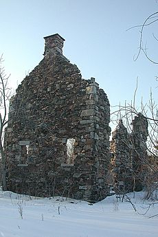
Today, you can still find the ruins of a stone house on the island. There is also an old light that was once used to help boats navigate the waters. In older maps from 1966, the island was called Lynch Island.
See also
 In Spanish: Isla Dowker para niños
 | Emma Amos |
 | Edward Mitchell Bannister |
 | Larry D. Alexander |
 | Ernie Barnes |


