Dun Vulan facts for kids

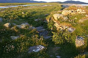
Eastern entrance of Dun Vulan
|
|
| Location | South Uist |
|---|---|
| Coordinates | 57°14′26″N 7°26′57″W / 57.240556°N 7.449167°W |
| Type | Broch |
| History | |
| Periods | Iron Age, Roman |
Dun Vulan Broch, known as 'Dùn Mhùlan' or 'Dùn Mhaoilinn' in Scottish Gaelic, is an amazing ancient stone tower. It's called a broch and was built during the Iron Age. You can find it on the island of South Uist in Scotland.
Where is Dun Vulan Broch?
Dun Vulan Broch is located on the island of South Uist. Today, it sits on a piece of land that sticks out into the sea. But long ago, when it was first built, it was actually next to a freshwater lake! Over time, the land and sea have changed.
What Does Dun Vulan Broch Look Like?
Dun Vulan is an Iron Age broch, built around 150 to 50 BC. It's found on the southern edge of a rocky point. The broch is now protected by a sea wall to keep it safe from the ocean.
When archaeologists dug up the site, they found that the broch is shaped like an oval. It measures about 19.5 metres across at its widest point. The walls are still standing up to 4.5 metres high and are 4 metres thick. Imagine how strong those walls must have been!
The History of Dun Vulan
Archaeologists worked at Dun Vulan Broch between June 1991 and July 1996. This big project was part of something called the SEARCH Project. SEARCH stands for the Sheffield Environmental and Archaeological Research Campaign in the Hebrides.
During their digs, the archaeologists looked for clues about the broch. They found that there were no older buildings on this spot before the main broch was constructed. This means the broch was likely the very first big structure built there.
 | Shirley Ann Jackson |
 | Garett Morgan |
 | J. Ernest Wilkins Jr. |
 | Elijah McCoy |


