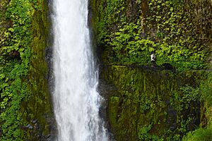
Eagle Creek Upper Falls facts for kids
Quick facts for kids Upper Eagle Creek Falls |
|
|---|---|

Tunnel Falls, Eagle Creek Trail
|
|
| Lua error in Module:Infobox_mapframe at line 185: attempt to index field 'wikibase' (a nil value). | |
| Location | Clackamas County, Oregon, United States |
| Coordinates | 45°16′39″N 122°11′41″W / 45.27762°N 122.19474°W |
| Elevation | 955 ft (291 m) |
Eagle Creek Upper Falls, also known as Upper Eagle Creek Falls, is a small waterfall in Clackamas County, Oregon, in the United States. This waterfall is special because it has a fish ladder. A fish ladder helps fish swim past the waterfall easily. Eagle Creek is also a great place for fishing for types of salmon and trout.
Upper Eagle Creek Falls is located upstream from the Eagle Creek National Fish Hatchery. This hatchery is a popular starting point for people who like to go kayaking down Eagle Creek. Many other waterfalls, like the famous Tunnel Falls, are found along the Eagle Creek Trail.
Contents
The Eagle Creek Fire
On September 2, 2017, a wildfire started in the Eagle Creek area. This fire affected almost half of the forest, mostly on the ground. Before this, there had never been such a big fire in Eagle Creek. Luckily, the hiking trails and campground were not damaged. The fire brought a lot of attention to Eagle Creek, which might make more people want to visit.
The Eagle Creek Fire was a wildfire in the Columbia River Gorge in Oregon and Washington. It started when teenagers reportedly set off fireworks during a time when fires were not allowed. The fire burned a large area of land. Rain helped to slow down the fire. By November 30, 2017, the fire was fully under control.
Because of the fire, a major highway had to close. For safety, over 4,000 trees were cut down. These trees were given to the U.S. Forest Service to help with nature restoration projects. The fire affected land owned by private citizens, the state, and the national government.
Fun Things to Do and Safety Tips
The Eagle Creek Park campground can host many visitors. It was built around 1930 by the Civilian Conservation Corps. From here, visitors can go kayaking in the creek. They can also hike to beautiful waterfalls like Tunnel Falls and Punch Bowl Falls. Along the Eagle Creek Trail, you can see amazing views of the Cascade Mountain Range and the Columbia River Gorge.
The Eagle Creek trailhead is a very busy place, especially on weekends. It's where many trails begin. Hikers, long-distance walkers on the Pacific Crest Trail, and people enjoying picnics all use this area. Visitors also come to see the nearby fish hatcheries and camp at Eagle Creek Campground.
It's important to keep your belongings safe when visiting the trailhead. Sometimes, people have reported items being taken from cars. It's a good idea not to leave valuable things in your car. Some hikers even take all their important items with them on the trail.
Signs suggest parking at the lower parking area, near the fish hatchery. This area often has people around, and there's a window looking out onto the parking lot. During summer, a camp host is also there. Parking here adds about half a mile to your hike, but it can be a safer option.
A Look Back in Time
The nonprofit Eagle Creek Park Foundation helps the park with money and volunteers. The park itself was started around 1910. Eagle Creek was developed around 1930 by the Civilian Conservation Corps. It was meant to be part of the Pacific Crest Trail.
J.K. Lilly Jr. bought some land in 1934 that later became Eagle Creek Park. In the 1950s, she gave her land to Purdue University. The university then sold some of this land to Marion County. Because Lilly was the first to buy the land, a library was named in her honor in 1973. Five years later, the Eagle Creek Park Foundation was created.
The Park Foundation provides park maps and passes. It costs a small fee to enter the park, but seniors can enter for free. The Foundation also supports learning about nature. They have helped the Ornithology Center and held bird-watching games for children.
Exploring the Trail
The Eagle Creek trail was finished in 1983 and updated in 1998. Currently, the trail cannot be visited. Because of the Eagle Creek Fire, many national forest lands in the Columbia River Gorge are closed. This closure will last until further notice. You can find more information on the USDA Forest Service Website.
Eagle Creek is a creek in Hood River County, Oregon. It flows into the Columbia River in Multnomah County. The creek is located in the Mount Hood National Forest. The Eagle Creek Trail, which is very popular, follows the creek.
Tunnel Falls and Punch Bowl Falls are two beautiful waterfalls along Eagle Creek. They are in a remote and scenic area. A historic highway crosses where the creek meets the Columbia River. You need to hike through some rough areas to reach the main Eagle Creek waterfall.
The Eagle Creek Trail was built in the 1930s by the CCC and WPA. It was originally part of the Pacific Crest Trail. The PCT was later moved to a different route. You can find extra parking near the Cascade Fish Hatchery. This is located off Interstate 84.
 | Bessie Coleman |
 | Spann Watson |
 | Jill E. Brown |
 | Sherman W. White |


