Eel River (Massachusetts) facts for kids
Quick facts for kids Eel River |
|
|---|---|

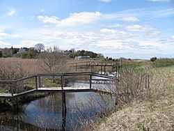
Footbridges over the Eel River
|
|
| Country | United States |
| Physical characteristics | |
| Main source | Springs and small ponds above Russell Millpond |
| River mouth | Plymouth Harbor |
| Length | 3.9 mi (6.3 km) |
| Basin features | |
| Basin size | 15 sq mi (39 km2) |
| Tributaries |
|
The Eel River is a small but important river in Plymouth, Massachusetts. It is about 3.9-mile (6.3 km) long. Most of the river flows through a village called Chiltonville.
The river starts from springs and small ponds. These are found above a place called Russell Millpond. The area that collects water for the river is about 15 square miles (39 km2). This area is called its watershed. The Eel River flows past famous places like Plimoth Plantation. It also runs along Plymouth Beach. Finally, it empties into Plymouth Harbor. This happens between the beach and a spot called Manters Point.
Where Does the Eel River Flow?
The Eel River flows through several interesting spots. It passes under different roads and paths. These crossings help people and vehicles get around.
Here is a list of the main crossings over the Eel River. The list starts from where the river begins and moves towards the sea.
- Russell Mills Road
- Route 3
- Sandwich Road
- River Street
- Plimoth Plantation Highway
- Warren Avenue (Route 3A)
What Streams Join the Eel River?
Rivers often have smaller streams that flow into them. These smaller streams are called tributaries. They add more water to the main river.
The Eel River has one main named tributary. It is called Shingle Brook. Shingle Brook joins the Eel River on its journey to the harbor.
 | Laphonza Butler |
 | Daisy Bates |
 | Elizabeth Piper Ensley |

