
El Peñol, Antioquia facts for kids
Quick facts for kids
El Peñol
|
|||
|---|---|---|---|
|
Municipality and town
|
|||
.JPG) |
|||
|
|||

Location of the municipality and town of Peñol in the Antioquia Department of Colombia
|
|||
| Country | |||
| Department | Antioquia Department | ||
| Area | |||
| • Total | 125 km2 (48 sq mi) | ||
| Population
(Census 2018)
|
|||
| • Total | 16,223 | ||
| • Density | 129.8/km2 (336.1/sq mi) | ||
| Time zone | UTC-5 (Colombia Standard Time) | ||
.svg)

El Peñol is a town and a special kind of local government area called a municipality in the Antioquia Department of Colombia. In 2018, about 16,223 people lived there. It's located in a part of Colombia known as Eastern Antioquia. El Peñol is famous because of a huge rock nearby, also called El Peñol, which many tourists love to visit.
Contents
History of El Peñol
Early Beginnings and Indigenous People
The town of El Peñol was first started in 1714. It was built along the Negro-Nare River. A person named Fray Miguel de Castro y Rivadeneiro founded it. Before the Spanish arrived, the area was home to the Tahamí people, who were an indigenous group.
Building a New Town: The Dam Project
In 1971, a company called Empresas Públicas de Medellín needed more water and power. This was to support the fast-growing city of Medellín, which is about 50 miles (80 km) away. They decided to build a dam on the Negro-Nare River near Guatapé. This meant the valley where the old El Peñol was located would be flooded.
The old town was taken over by the government for public use. A brand new town was built a few miles to the west. Many thousands of people had to move to this new town.
The Flooding of the Old Town
The new dam was finished, and the valley was flooded in 1978. Today, the El Peñol-Guatapé Reservoir covers the spot where the old town of El Peñol used to be. You can still see a cross in the reservoir. This cross marks the place where the old church, or parish, of El Viejo Peñol once stood in the town square. Some parts of the nearby town of Guatapé were also flooded.
Climate in El Peñol
El Peñol has a type of weather called a subtropical highland climate. This means it has warm temperatures all year round. It also gets a lot of rain. This kind of climate is often found in mountain areas.
| Climate data for El Peñol (Penol), elevation 1,956 m (6,417 ft), (1981–2010) | |||||||||||||
|---|---|---|---|---|---|---|---|---|---|---|---|---|---|
| Month | Jan | Feb | Mar | Apr | May | Jun | Jul | Aug | Sep | Oct | Nov | Dec | Year |
| Mean daily maximum °C (°F) | 22.6 (72.7) |
22.8 (73.0) |
23.2 (73.8) |
23.3 (73.9) |
23.7 (74.7) |
23.8 (74.8) |
23.9 (75.0) |
24.0 (75.2) |
23.6 (74.5) |
23.0 (73.4) |
22.6 (72.7) |
22.5 (72.5) |
23.3 (73.9) |
| Daily mean °C (°F) | 17.8 (64.0) |
18.0 (64.4) |
18.1 (64.6) |
18.3 (64.9) |
18.6 (65.5) |
18.8 (65.8) |
18.7 (65.7) |
18.7 (65.7) |
18.3 (64.9) |
18.0 (64.4) |
17.8 (64.0) |
17.7 (63.9) |
18.2 (64.8) |
| Mean daily minimum °C (°F) | 12.8 (55.0) |
13.0 (55.4) |
13.0 (55.4) |
13.1 (55.6) |
13.3 (55.9) |
13.0 (55.4) |
12.7 (54.9) |
12.8 (55.0) |
12.6 (54.7) |
12.6 (54.7) |
12.7 (54.9) |
12.7 (54.9) |
12.9 (55.2) |
| Average precipitation mm (inches) | 113.2 (4.46) |
112.0 (4.41) |
181.0 (7.13) |
270.2 (10.64) |
296.6 (11.68) |
201.4 (7.93) |
207.7 (8.18) |
236.8 (9.32) |
295.5 (11.63) |
317.6 (12.50) |
220.4 (8.68) |
153.2 (6.03) |
2,605.6 (102.58) |
| Average precipitation days (≥ 1.0 mm) | 15 | 15 | 20 | 24 | 23 | 19 | 19 | 20 | 24 | 25 | 23 | 19 | 238 |
| Average relative humidity (%) | 86 | 86 | 86 | 87 | 86 | 83 | 82 | 83 | 85 | 86 | 87 | 87 | 86 |
| Source: Instituto de Hidrologia Meteorologia y Estudios Ambientales | |||||||||||||
Images for kids
-

The former location of El Peñol
-
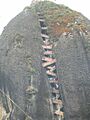
El Peñol rock, next to Guatapé dam


See also
 In Spanish: El Peñol (Antioquia) para niños
