
El Sena facts for kids
Quick facts for kids
El Sena
|
|
|---|---|
 |
|

El Sena
Location in Bolivia
|
|
| Country | |
| Department | Pando Department |
| Province | Madre de Dios Province |
| Municipality | El Sena Municipality |
| Canton | Bolívar Canton |
| Elevation | 3,800 m (12,500 ft) |
| Population
(2012)
|
|
| • Total | 2,587 |
| Time zone | UTC-4 (BOT) |
El Sena is a small village located in the Madre de Dios Province. This province is part of the Pando Department in the country of Bolivia. El Sena is also the main town, or capital, of the El Sena Municipality.
Contents
Where is El Sena Located?
El Sena is found in the northern part of Bolivia. It is in the Pando Department, which is known for its Amazon rainforest environment. The village is situated at a high elevation of about 3,800 meters (12,467 feet) above sea level. Its exact coordinates are 11°29′2″S latitude and 67°14′52″W longitude.
What is the Pando Department?
The Pando Department is one of the nine departments of Bolivia. It is in the Amazon basin, meaning it has a tropical climate. This area is rich in biodiversity, with many different plants and animals. The capital city of the Pando Department is Cobija.
What is Madre de Dios Province?
Madre de Dios Province is one of the five provinces within the Pando Department. El Sena is located within this province. The name "Madre de Dios" means "Mother of God" in Spanish.
How Many People Live in El Sena?
According to the 2012 census, El Sena had a population of 2,587 people. This makes it a relatively small community. The people living here are part of the larger El Sena Municipality.
What is the Time Zone in El Sena?
El Sena uses the Bolivia Time (BOT) zone. This means it is 4 hours behind Coordinated Universal Time (UTC-4). There is no daylight saving time observed in El Sena.
See also

- In Spanish: Sena (Pando) para niños
Images for kids
-
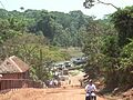
A view of El Sena, Pando.
