Emiliano Zapata, Jalisco facts for kids
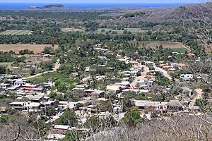
Emiliano Zapata is a lively village located in the Mexican state of Jalisco. It's part of the La Huerta area, found on the beautiful south coast of Jalisco. This village is right on Highway 200, which connects Barra de Navidad and Puerto Vallarta. It's also part of a popular tourist spot called Costalegre, known for its lovely beaches and scenery. Emiliano Zapata is one of the biggest villages in La Huerta, and it's so close to a neighboring village called Francisco Villa that they almost blend together!
Contents
About Emiliano Zapata
Emiliano Zapata sits very close to sea level, at an altitude of just 10 meters (about 33 feet). It is home to about 1,223 people. More than half of the people living here are adults. On average, people in Emiliano Zapata attend school for about six years. The village is located at these coordinates: 19.382778 degrees North and 104.965278 degrees West.
What Can You Find in Emiliano Zapata?
Emiliano Zapata offers many useful facilities and services for its residents and visitors. You can find a main park, a football field, and even a bullring. There are also grocery stores, restaurants, and places to get your car fixed. For personal care, there are barbershops and a gym. If you need to connect online, cyber cafes are available. The village also has medical facilities and doctors. For spiritual needs, there is the Church of Our Lady of Perpetual Help.
Fun Events and Celebrations
Emiliano Zapata hosts two major events each year that bring the community together:
- "20 de Noviembre" Fest: This festival celebrates a special day in November. It includes exciting traditional bull riding shows and artistic performances.
- Religious Fest on June 27: This event honors Our Lady of Perpetual Help. It features popular pilgrimages where people walk together to show their devotion.
See also
 In Spanish: Emiliano Zapata (Jalisco) para niños


